
-
Himawari-08 AHI Deep Blue Aerosol L2
The Himawari-08 AHI Deep Blue Aerosol L2 Full Disk product, short-name AERDB_L2_AHI_H08 is produced every 30 minutes and contains full-disk observation data. The L2 data... -
Reduced Resolution Geophysical Product for Ocean, Land and Atmosphere
The Medium Resolution Imaging Spectrometer (MERIS) is one of 10 sensors deployed in March of 2002 on board the polar-orbiting Envisat-1 environmental research satellite by the... -
VIIRS/JPSS2 Raw Radiances in Counts 6-Min L1A Swath
The Near Real Time (NRT) VIIRS/JPSS2 Raw Radiances in Counts 6-Min L1A Swath, short-name VJ201_NRT data product contains the unpacked, raw VIIRS science, calibration and... -
Sounder SIPS: Suomi NPP CrIMSS Level 3 Specific Quality Control Gridded Daily CHART Normal Spectral Resolution V1
The objective of this limited edition data collection is to examine products generated by the Climate Heritage AIRS Retrieval Technique (CHART) algorithm to analyze Cross-track... -
Sounder SIPS: AQUA AIRS IR-only Level 2 CLIMCAPS : Atmosphere, cloud and surface geophysical state V2 (SNDRAQIL2CCPRET) at GES DISC
WARNING: To users of the derived product “co_mmr_midtrop” (carbon monoxide mass mixing ratio to dry air [kg/kg] at ~500 hPa). This variable has a significant bias due to a... -
VIIRS/NPP Imagery Resolution Terrain Corrected Geolocation 6-Min L1 Swath 375 m
The VIIRS/NPP Imagery Resolution Terrain-Corrected Geolocation 6-Min L1 Swath 375m, short-name VNP03IMG, product contains the derived line-of-sight (LOS) vectors for each of the... -
VNP02MOD | VIIRS/NPP Moderate Resolution 6-Min L1B Swath 750 m
The VNP02MOD | VIIRS/NPP Moderate Resolution 6-Min L1B Swath 750m, short-name VNP02MOD contains the derived line-of-sight (LOS) vectors for each of the 750-m moderate-... -
MODIS/Aqua Aerosol 5-Min L2 Swath 10km NGDA
The MODIS/Aqua Aerosol 5-Min L2 Swath 10km product (MYD04_L2) provides full global coverage of aerosol properties from the Dark Target (DT) and Deep Blue (DB) algorithms. The DT... -
Sounder SIPS: Suomi NPP CrIMSS Level 3 Specific Quality Control Gridded Daily CLIMCAPS Full Spectral Resolution V2 at GES DISC
WARNING: To users of the derived product “co_mmr_midtrop” (carbon monoxide mass mixing ratio to dry air [kg/kg] at ~500 hPa). This variable has a significant bias due to a... -
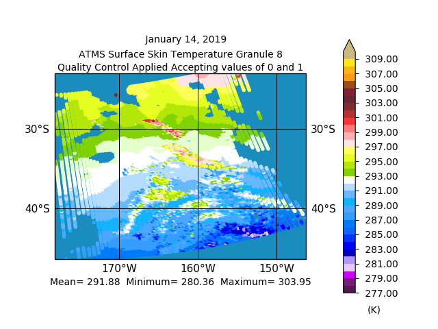
Sounder SIPS: JPSS-1 ATMS Level 2 RAMSES2 Support V3 (SNDRJ1ML2RMSSUP) at GES DISC
This level 2 support product is generated by the RAMSES (Retrieval Algorithm for Microwave Sounders in Earth Science) II algorithm.The RAMSES II algorithm is a microwave only... -
STAQS SeaRey Data
STAQS_SeaRey_Data is the data collected onboard the Progressive Aerodyne SeaRey aircraft during the Synergistic TEMPO Air Quality Science (STAQS) mission. Data collection for... -
VIIRS/JPSS1 Moderate Resolution Terrain Corrected Geolocation L1 6-Min Swath 750m
The VIIRS/JPSS1 Moderate Resolution Terrain Corrected Geolocation 6-Min L1 Swath 750m product, short-name VJ103MOD contains the derived line-of-sight (LOS) vectors for each of... -
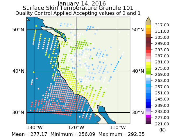
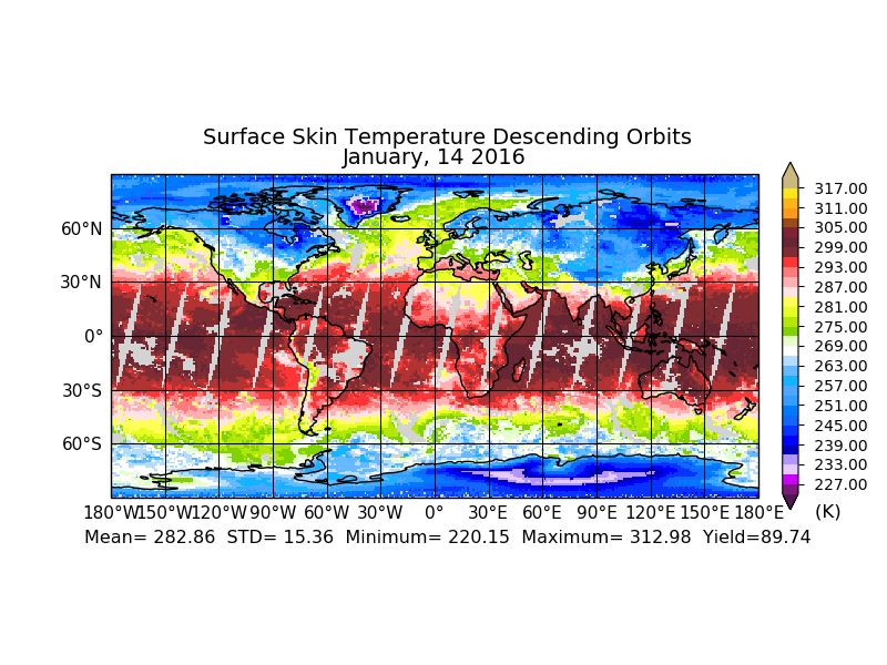
MODIS/Terra Land Surface Temperature/3-Band Emissivity 5-Min L2 1km NRT NGDA
The MODIS/Terra Land Surface Temperature/3-Band Emissivity (LST&E) 5-Min L2 1km data product, short-name MOD21 is produced daily in five minute temporal increments of... -
MODIS/Terra Total Precipitable Water Vapor 5-Min L2 Swath 1km and 5km NGDA
The MODIS/Terra Total Precipitable Water Vapor 5-Min L2 Swath 1km and 5km (MOD05_L2) product consists of atmospheric column water-vapor amounts. This product is derived from... -
STAQS Balloonsondes and Ozonesondes Data
STAQS_Sondes_Data is the balloonsonde and ozonesonde data collected during the Synergistic TEMPO Air Quality Science (STAQS) mission. Data collection for this product is... -
GOES17 ABI Deep Blue Aerosol L2
The ABI G17 Deep Blue Aerosol 10-Min L2 Full Disk product, short-name AERDB_L2_ABI_G17 is produced every 30 minutes and contains full-disk observation data. The L2 data products... -
MODIS/Terra Level 1B Subsampled Calibrated Radiance 5Km NGDA
The MODIS/Terra Level 1B Subsampled Calibrated Radiances 5km (MOD02SSH) is a subsample from the MODIS Level 1B 1-km data. Every fifth pixel is taken from the MOD021KM product... -
VIIRS/NPP BRDF/Albedo Model Parameters Daily L3 Global 1km SIN Grid V001
The NASA/NOAA Suomi National Polar-orbiting Partnership (Suomi NPP) Visible Infrared Imaging Radiometer Suite (VIIRS) Bidirectional Reflectance Distribution Function (BRDF) and...

Official websites use .gov
A
.gov website belongs to an official government
organization in the United States.
Secure .gov websites use HTTPS
A
lock (
) or https:// means you’ve safely connected to
the .gov website. Share sensitive information only on official,
secure websites.