
-
Indir Jaganjac
FLTz flight simulator RecorderRun9 data are analyzed in order to compute systems health score using Granger causal connectovity analysis. First G-causality is computed, and then... -
ABoVE: Seasonal Dissolved Gases and Isotopes in Arctic Alaska Rivers
This dataset provides dissolved carbon dioxide (CO2) and methane (CH4) concentrations alongside their stable and radiocarbon isotopic compositions within the Arctic... -
Aquarius Official Release Level 3 Wind Speed Standard Mapped Image Descending Seasonal Data V5.0
Aquarius Level 3 ocean surface wind speed standard mapped image data contains gridded 1 degree spatial resolution wind speed data averaged over daily, 7 day, monthly, and... -
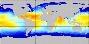
Aquarius Official Release Level 3 Rain-flagged Sea Surface Salinity Standard Mapped Image Ascending Mission Cumulative Data V5.0
Aquarius Level 3 sea surface salinity (SSS) standard mapped image data contains gridded 1 degree spatial resolution SSS averaged over daily, 7 day, monthly, and seasonal time... -
Delta-X AVIRIS-NG L3 Derived Vegetation Types, MRD, Louisiana, USA
This dataset provides maps of vegetation types for the Atchafalaya and Terrebonne basins in coastal Louisiana, U.S., derived from NASA's Next Generation Airborne Visible... -
Aquarius Official Release Level 3 Sea Surface Spiciness Standard Mapped Image Ascending Monthly Climatology Data V5.0
Aquarius Level 3 sea surface spiciness standard mapped image data contains gridded 1 degree spatial resolution spice data averaged over daily, 7 day, monthly, and seasonal time... -
Aquarius Official Release Level 3 Rain-flagged Sea Surface Salinity Standard Mapped Image Ascending Seasonal Data V5.0
Aquarius Level 3 sea surface salinity (SSS) rain-flagged standard mapped image data contains gridded 1 degree spatial resolution SSS averaged over daily, 7 day, monthly, and... -
Flight Data For Tail 683
The following zip files contain individual flight recorded data in Matlab file format. There are 186 parameters each with a data structure that contains the following: -sensor... -
Gazetteer of Planetary Nomenclature
Planetary nomenclature, like terrestrial nomenclature, is used to uniquely identify a feature on the surface of a planet or satellite so that the feature can be easily located,... -
Aquarius Official Release Level 3 Rain-flagged Sea Surface Salinity Standard Mapped Image Descending Seasonal Data V5.0
Aquarius Level 3 sea surface salinity (SSS) rain-flagged standard mapped image data contains gridded 1 degree spatial resolution SSS averaged over daily, 7 day, monthly, and... -
Aquarius Official Release Level 3 Sea Surface Density Standard Mapped Image Descending Annual Data V5.0
Aquarius Level 3 sea surface density standard mapped image data contains gridded 1 degree spatial resolution density data averaged over daily, 7 day, monthly, and seasonal time... -
Aquarius Official Release Level 3 Sea Surface Density Standard Mapped Image Monthly Climatology Data V5.0
Aquarius Level 3 sea surface density standard mapped image data contains gridded 1 degree spatial resolution derived density averaged over daily, 7 day, monthly, and seasonal... -
Aquarius Official Release Level 3 Ancillary Reynolds Sea Surface Temperature Standard Mapped Image Ascending Seasonal Climatology Data V5.0
Aquarius Level 3 ancillary sea surface temperature (SST) standard mapped image data are the ancillary SST data used in the Aquarius calibration for salinity retrieval. They are... -
CIDU 2010 paper template
CIDU 2010 LaTeX and Microsoft Word templates. -
NJFCP Lean blowout data
Lean blowout data using fuels from the National Jet Fuels Combustion Program (NJFCP). Testing was done in the CE-13C flametube with the NASA 7-point swirl-venturi (SV-) lean... -
IT Policy Archive
CIO defines IT processes and policies. The CIO defines the development processes, milestones, review gates, and the overall policies for all capital planning, enterprise... -
Stratospheric Aerosol and Gas Experiment (SAGE) II Version 7.0 Aerosol, O3, NO2 and H2O Profiles in binary format
SAGE2_AEROSOL_O3_NO2_H2O_BINARY_V7.0 is the Stratospheric Aerosol and Gas Experiment (SAGE) II Version 7.0 Aerosol, O3, NO2 and H2O Profiles data set in the SAGE II native... -
Aquarius Official Release Level 3 Rain-flagged Sea Surface Salinity Smoothed Standard Mapped Image Ascending Monthly Data V5.0
Aquarius Level 3 sea surface salinity (SSS) standard mapped image data contains gridded 1 degree spatial resolution SSS averaged over daily, 7 day, monthly, and seasonal time... -
Aquarius Official Release Level 3 Wind Speed Standard Mapped Image Seasonal Data V5.0
Aquarius Level 3 ocean surface wind speed standard mapped image data contains gridded 1 degree spatial resolution wind speed data averaged over daily, 7 day, monthly, and...

Official websites use .gov
A
.gov website belongs to an official government
organization in the United States.
Secure .gov websites use HTTPS
A
lock (
) or https:// means you’ve safely connected to
the .gov website. Share sensitive information only on official,
secure websites.