
-
TES/Aura L2 Ancillary Product V008
TL2ANC_8 is the Tropospheric Emission Spectrometer (TES)/Aura Level 2 Ancillary Version 8 product . TES Level 2 data contain retrieved species (or temperature) profiles at the... -
TES/Aura L2 Instantaneous Radiative Kernel Nadir Special Observation V008
TL2IRKNS_8 is the Tropospheric Emission Spectrometer (TES)/Aura Level 2 Instantaneous Radiative Kernel Nadir Special Observation Version 8 data product. TES was an instrument... -
CERES Regionally Averaged TOA Fluxes, Clouds and Aerosols Hourly Aqua Edition4A NGDA
CER_SSF1deg-Hour_Aqua-MODIS_Edition4A is the Clouds and the Earth's Radiant Energy System (CERES) Regionally Averaged Top of Atmosphere (TOA) Fluxes, Clouds and Aerosols Hourly... -
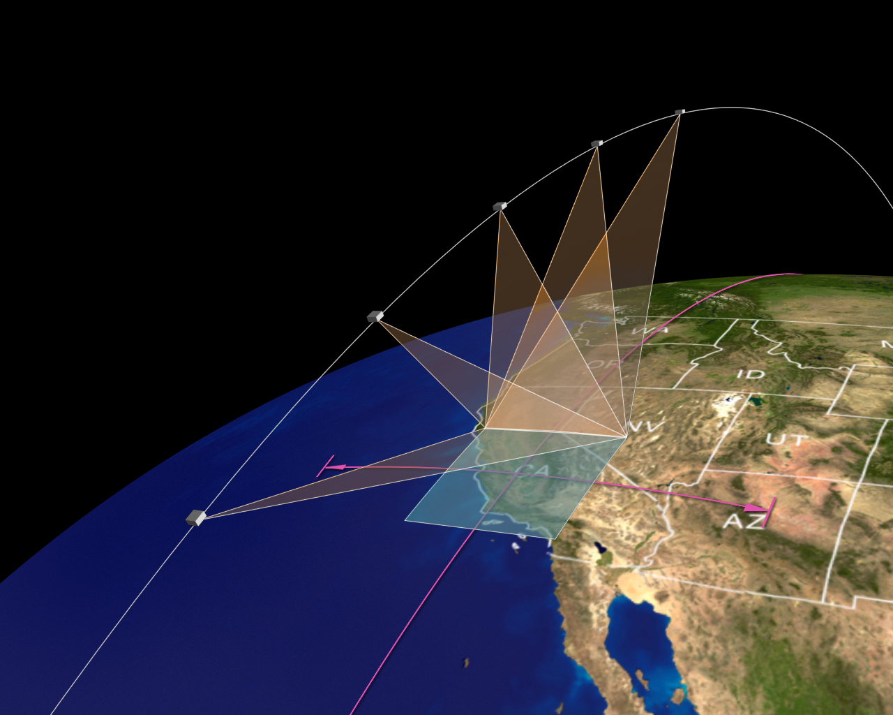
AirMSPI verison 6 ellipsoid-projected georegistered radiance product acquired during the RADEX flight campaign
AirMSPI_RADEX_Ellipsoid-projected_Georegistered_Radiance_Data is an AirMSPI ellipsoid-projected georegistered radiance product acquired during the Radar Definition Experiment... -
STAQS Chiwaukee Prairie Data
STAQS_Chiwaukee-Prairie_Data is the data collected at the Chiwaukee Prairie site during the Synergistic TEMPO Air Quality Science (STAQS) mission. Data collection for this... -
Aeolus CalVal DAWN Wind Profiles
AEOLUS-CALVAL-DAWN_DC8_1 is the Aeolus CalVal DAWN (Doppler Aerosol WiNd) Lidar Wind Profiles data product. Data was collected using the DAWN instrument on the Douglas (DC-8)... -
Ancillary total PM data from the MAIA Surface Monitor Network
The MAIA Surface Monitor Stage 0 files are an ancillary dataset containing processed particulate matter (PM) measurements collected from a global in-situ surface monitoring... -
ARCTAS DC-8 Aircraft In-situ Photolysis Rate Data
ARCTAS_JValue_AircraftInSitu_DC8_Data is the in-situ photolysis rate data collected by the DC-8 aircraft during the Arctic Research of the Composition of the Troposphere from... -
SEAC4RS ER-2 Aircraft In-Situ Radiation Data
SEAC4RS_Radiation_AircraftInSitu_ER2_Data are in-situ radiation data collected onboard the ER-2 aircraft during the Studies of Emissions and Atmospheric Composition, Clouds and... -
GEWEX SRB Integrated Product (Rel-4) Shortwave 3-Hourly Monthly Average by UTC Fluxes
GEWEXSRB_Rel4-IP_Shortwave_3hrlymonthly_utc is the Global Energy and Water Exchanges (GEWEX) Surface Radiation Budget (SRB) Integrated Product (Rel-4) Shortwave 3-Hourly Monthly... -
CALIPSO Lidar Level 2 5 km Merged Layer, V4-20
CAL_LID_L2_05kmMLay-Standard-V4-20 is the Cloud-Aerosol Lidar and Infrared Pathfinder Satellite Observations (CALIPSO) Lidar Level 2 5 km Merged Layer, Version 4-20 data... -
DISCOVER-AQ California Deployment Bakersfield Ground Site Data
DISCOVERAQ_California_Ground_Bakersfield_Data contains data collected at the Bakersfield ground site during the California (San Joaquin Valley) deployment of NASA's DISCOVER-AQ... -
NARSTO EPA Supersite (SS) Fresno, Aethalometer Multi-Wavelength Carbon Data
NARSTO_EPA_SS_FRESNO_AETHALOM_MULTI_WL_CARBON is the North American Research Strategy for Tropospheric Ozone (NARSTO) Environmental Protection Agency (EPA) Supersite (SS)... -
Measurement of Air Pollution from Satellites (MAPS) Space Radar Laboratory - 1 (SRL1) Carbon Monoxide 5 degree by 5 degree data
MAPS OverviewThe MAPS experiment measures the global distribution of carbon monoxide (CO) mixing ratios in the free troposphere. Because of MAPS' previous flights on board the... -
First ISCCP Regional Experiment (FIRE) Cirrus 1 Surface Radiation Budget (SRB) Data over Canada
The First ISCCP Regional Experiments have been designed to improve data products and cloud/radiation parameterizations used in general circulation models (GCMs). Specifically,... -
CERES Time-Interpolated TOA Fluxes, Clouds and Aerosols Daily Terra Edition4A
CER_SSF1deg-Day_Terra-MODIS_Edition4A is the Clouds and the Earth's Radiant Energy System (CERES) Time-Interpolated Top of Atmosphere (TOA) Fluxes, Clouds and Aerosols Daily... -
TES/Aura L3 Carbon Monoxide Monthly Gridded V005
TL3COM_5 is the Tropospheric Emission Spectrometer (TES)/Aura Level 3 Carbon Monoxide Monthly Gridded Version 5 data product. TES was an instrument aboard NASA's Aura satellite... -
SASS (Subsonics Assessment) Ozone and NOx Experiment (SONEX) DC-8 In-Situ Meteorological and Navigation Data
SONEX_TraceGas_AircraftInSitu_DC8_Data_1 is the in-situ meteorological and navigation data collected onboard the DC-8 aircraft during the SASS (Subsonics Assessment) Ozone and... -
AirMSPI verison 6 ellipsoid-projected georegistered radiance product acquired during the ImPACT-PM flight campaign
AirMSPI_ImPACT-PM_Ellipsoid-projected_Georegistered_Radiance_Data is an AirMSPI ellipsoid-projected georegistered radiance product acquired during the JPL and Caltech Imaging... -
TES/Aura L3 Ozone Daily Gridded V005
TL3O3D_5 is the Tropospheric Emission Spectrometer (TES)/Aura L3 Ozone Daily Gridded Version 5 data product. TES was an instrument aboard NASA's Aura satellite and was launched...

Official websites use .gov
A
.gov website belongs to an official government
organization in the United States.
Secure .gov websites use HTTPS
A
lock (
) or https:// means you’ve safely connected to
the .gov website. Share sensitive information only on official,
secure websites.