
-
National Oceanographic Partnership Program ARGO profiling floats
Measurements from the NOPP (National Oceanographic Partnership Program) as collected by ARGO profiling floats. -
VISUAL IMAGING AND PHOTOMETRY OF (29981) 1999 TD10 V1.0
The outer solar system object (29981) 1999 TD10 was observed in the R band in September 2001, and in B, V, R, and I in October 2002. We derive B- V=0.80+/-0.05mag,... -
Gulf of Guinea climate and ocean circulation study (EGEES)
Measurements made in the Gulf of Guinea off of west-central Africa in 2007 as part of the fifth cruise in the EGEE project (Gulf of Guinea climate and ocean circulation study,... -
ABoVE: Light-Curve Modelling of Gridded GPP Using MODIS MAIAC and Flux Tower Data NGDA
This dataset contains gridded estimations of daily ecosystem Gross Primary Production (GPP) in grams of carbon per day at a 1 km2 spatial resolution over Alaska and Canada from... -
Turbulence Models: Data from Other Experiments: 2-D Coanda Airfoil with Tangential Wall Jet
2-D Coanda Airfoil with Tangential Wall Jet. This web page provides data from experiments that may be useful for the validation of turbulence models. This resource is expected... -
Global-Gridded Daily Methane Emissions Climatology from Lake Systems, 2003-2015
This dataset provides global gridded information on lake surface area and open water CH4 emissions at a resolution of 0.25-degree x 0.25-degree for an annual climatology... -
GPM GROUND VALIDATION AUTONOMOUS PARSIVEL UNIT (APU) IPHEx V1
The GPM Ground Validation NASA Autonomous Parsivel Unit (APU) IPHEx dataset was acquired by multiple parsivel instruments during the GPM Integrated Precipitation and Hydrology... -
Gulf of Mexico and East Coast Carbon Cruise (GOMECC)
The Gulf of Mexico and East Coast Carbon Cruise (GOMECC) -
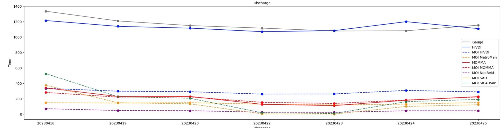
SWOT Sword of Science River Discharge Products Version 1
The SWOT Sword of Science River Discharge Products dataset from the Surface Water and Ocean Topography (SWOT) mission and produced by the Discharge Algorithm Working Group... -
Measurements in Lake Okeechobee, Florida, 1997 - 1999
Optical measurements made in Lake Okeechobee, Florida, between 1997 and 1999 -
First ISCCP Regional Experiment (FIRE) Atlantic Stratocumulus Transition Experiment (ASTEX) Rawinsonde Level 1 Data
The First ISCCP Regional Experiments have been designed to improve data products and cloud/radiation parameterizations used in general circulation models (GCMs). Specifically,... -
MERRA-2 instU_3d_asm_Np: 3d,diurnal,Instantaneous,Pressure-Level,Assimilation,Assimilated Meteorological Fields 0.625 x 0.5 degree V5.12.4 (M2IUNPASM) at GES DISC
M2IUNPASM (or instU_3d_asm_Np) is an instantaneous 3-dimensional monthly diurnal means data collection in Modern-Era Retrospective analysis for Research and Applications version... -
SAFARI 2000 TOMS Tropospheric Ozone Data, Southern Africa Subset, Dry Season 2000
Tropical Tropospheric Ozone (TTO) data from Earth Probe (EP) Total Ozone Mapping Spectrometer (TOMS) for the period of August 8-September 29, 2000 were processed and provided by... -
Land Cover Classification, Snow Cover, and Fractional Snow-Covered Area Maps from Maxar WorldView Satellite Images V001
This data set includes: (1) fine-scale snow and land cover maps from two mountainous study sites in the Western U.S., produced using machine-learning models trained to extract... -
Satellite Observations of Arctic Change, Version 1 NGDA
The purpose of this site is to expose NASA satellite data and research on Arctic change in the form of maps that illustrate the changes taking place in the Arctic over time. A... -
Quicklook Arctic Weekly EASE-Grid Sea Ice Motion Vectors, Version 1
This data set is the quicklook version of the Polar Pathfinder Daily 25 km EASE-Grid Sea Ice Motion Vectors product (https://nsidc.org/data/nsidc-0116). It contains weekly sea... -
NLDAS Primary Forcing Data L4 Monthly Climatology 0.125 x 0.125 degree V2.0 (NLDAS_FORA0125_MC) at GES DISC
This data set contains the monthly climatology data of the primary forcing data for Phase 2 of the North American Land Data Assimilation System (NLDAS-2). The data are in 1/8th...

Official websites use .gov
A
.gov website belongs to an official government
organization in the United States.
Secure .gov websites use HTTPS
A
lock (
) or https:// means you’ve safely connected to
the .gov website. Share sensitive information only on official,
secure websites.