
-
Georeferenced Population Datasets of Mexico (GEO-MEX): Raster Based GIS Coverage of Mexican Population
The Raster Based GIS Coverage of Mexican Population is a gridded coverage (1 x 1 km) of Mexican population. The data were converted from vector into raster. The population... -
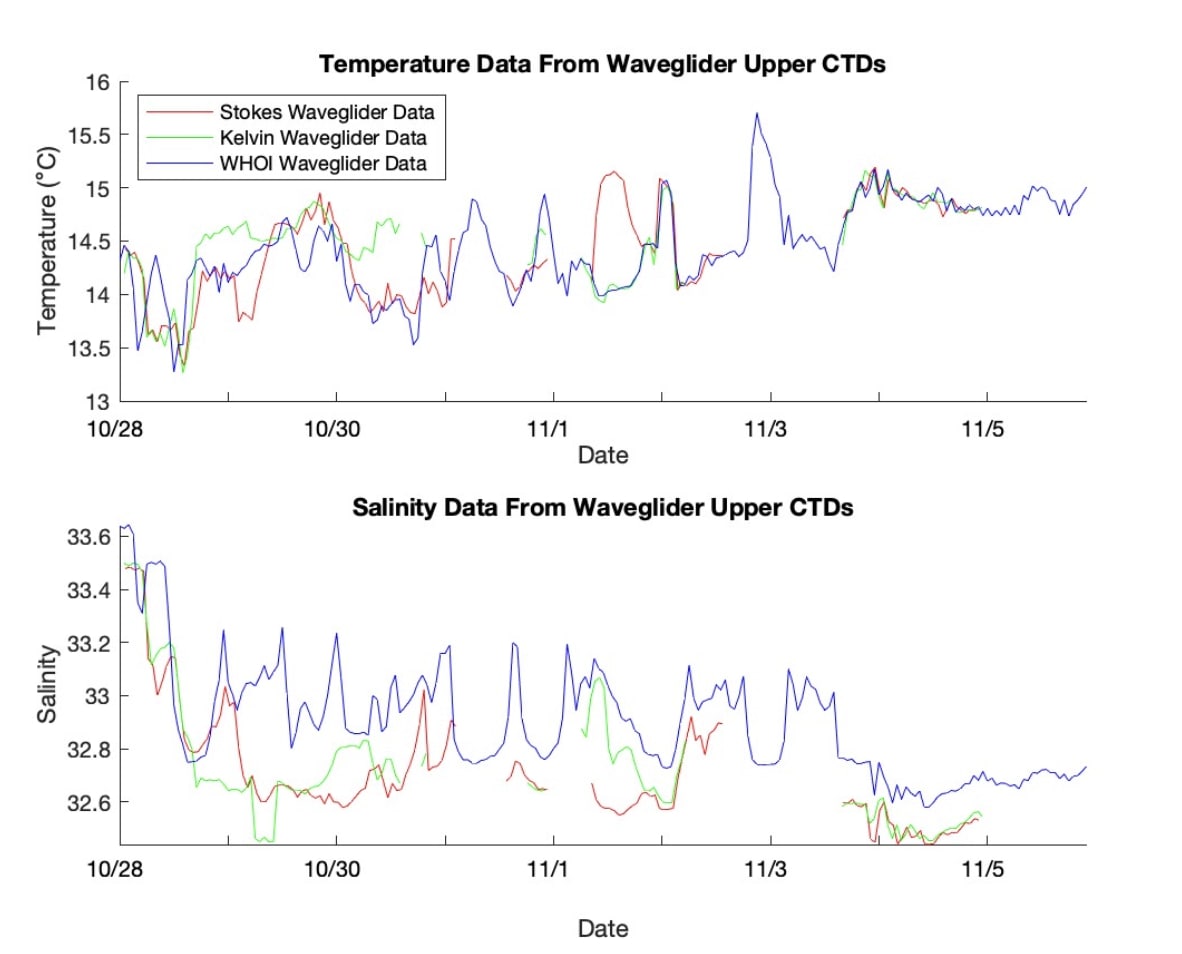
S-MODE Waveglider Observations
This dataset contains waveglider observations from the Sub-Mesoscale Ocean Dynamics Experiment (S-MODE) field campaign. The experiment was conducted approximately 300 km... -
Aboveground Biomass Density for High Latitude Forests from ICESat-2, 2020
This dataset provides estimates of Aboveground dry woody Biomass Density (AGBD) for high northern latitude forests at a 30-m spatial resolution. It is designed both for boreal-... -
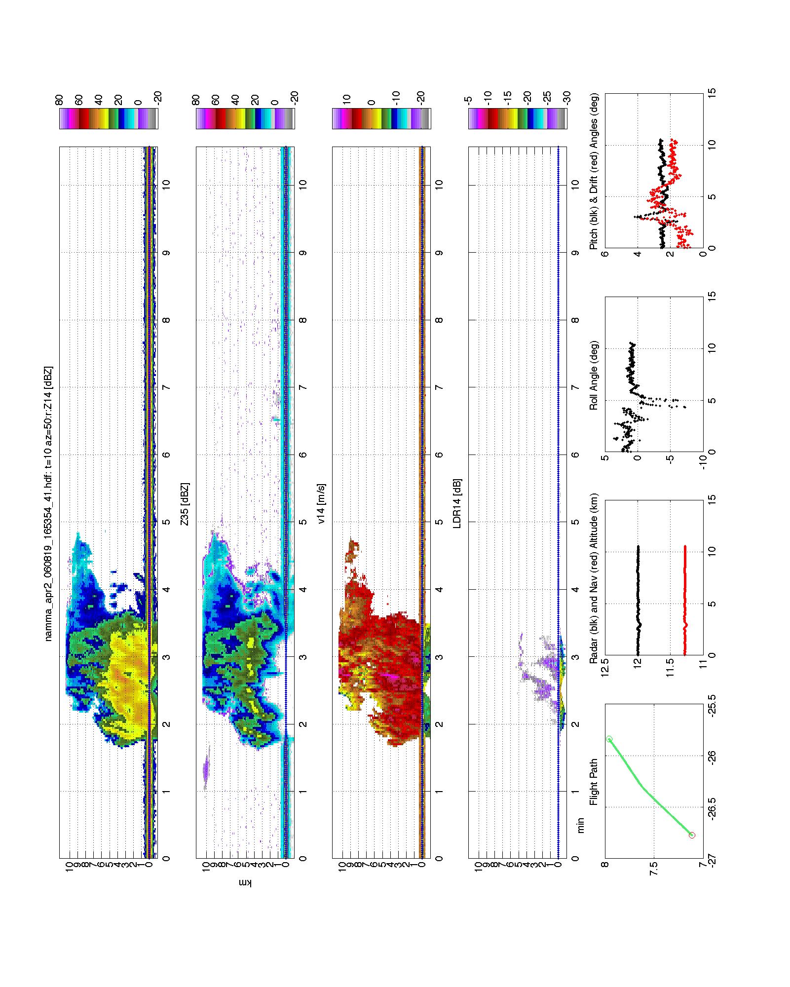
NAMMA SECOND GENERATION AIRBORNE PRECIPITATION RADAR (APR-2) V1
The NAMMA Second Generation Airborne Precipitation Radar (APR-2) dataset was collected by using the Second Generation Airborne Precipitation Radar (APR-2), which is a dual-... -
Aquarius Official Release Level 3 Rain-flagged Sea Surface Salinity Standard Mapped Image Seasonal Data V5.0
Aquarius Level 3 sea surface salinity (SSS) rain-flagged standard mapped image data contains gridded 1 degree spatial resolution SSS averaged over daily, 7 day, monthly, and... -
ABoVE: Soil Temperature Profiles, USArray Seismic Stations, AK and Canada, 2016-2019
This dataset includes soil temperature profile measurements taken at 16 monitoring sites in Alaska, USA, and at one site in Yukon, Canada. The six sites are collocated with... -
S-MODE PRISM Level 2a Reflectance Version 1
This dataset contains orthocorrected and atmospherically corrected water-leaving reflectance data from the Sub-Mesoscale Ocean Dynamics Experiment (S-MODE) during the IOP1... -
ACT-America: WRF-Chem Baseline Simulations for North America, 2016-2019
This dataset includes hourly output from the WRF-Chem simulation model for North America at a resolution of 27 km for 2016-06-29 through 2019-07-31. WRF-Chem is the Weather... -
S-MODE Pre-Pilot Ocean Wave Slope from Visible-Band Polarimetry at the Air-Sea Interaction Tower Version 1
These wave slope data from polarimetry described below are considered preliminary and should not be used for any purpose without consulting Chris Zappa... -
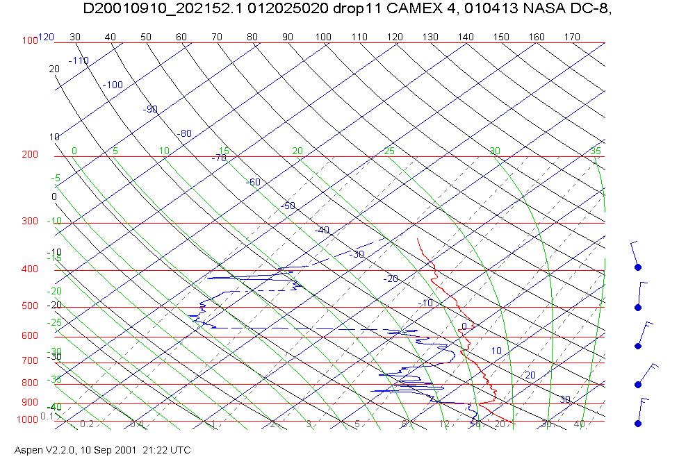
CAMEX-4 DC-8 DROPSONDE SYSTEM V1
The CAMEX-4 DC-8 Dropsonde System dataset was collected by the DC-8 Dropsonde System (D8D) uses dropwindsonde and Global Positioning System (GPS) receivers to measure the... -
Aquarius Official Release Level 3 Rain-flagged Sea Surface Salinity Standard Mapped Image Ascending 7-Day Data V5.0
Aquarius Level 3 sea surface salinity (SSS) rain-flagged standard mapped image data contains gridded 1 degree spatial resolution SSS averaged over daily, 7 day, monthly, and... -
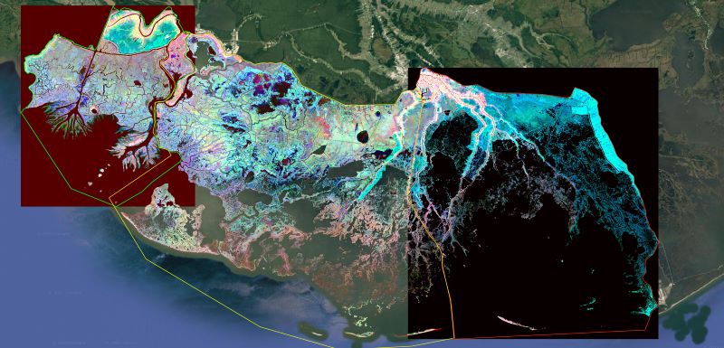
Delta-X: Ecogeomorphic Cell Products across the MRD, LA, USA, 2021
This product delineates the Mississippi River Delta (MRD) landscape into distinct ecogeomorphic cells, which are small contiguous areas of land with similar ecological and... -
Indicators of Coastal Water Quality: Ancillary Data
The Ancillary Data component of the Indicators of Coastal Water Quality Collection includes a 5 arc-minute (approximately 9 x 9 km at the equator) sequence grid, grid cell... -
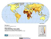
Poverty Mapping Project: Global Subnational Infant Mortality Rates
The Poverty Mapping Project: Global Subnational Infant Mortality Rates data set consists of estimates of infant mortality rates for the year 2000. The infant mortality rate for... -
OMPS-N21 L2 LP Ozone (O3) Vertical Profile swath daily 3slit V1.0 (OMPS_N21_LP_L2_O3_DAILY) at GES DISC
The OMPS-N21 L2 LP Ozone (O3) Vertical Profile swath daily 3slit collection contains ozone measured by the Ozone Mapping and Profiling Suite (OMPS) Limb-Profiler (LP) sensor on... -
ECOSTRESS Evaporative Stress Index dis-ALEXI Daily L4 CONUS 70 m V001
The ECOsystem Spaceborne Thermal Radiometer Experiment on Space Station (ECOSTRESS) mission measures the temperature of plants to better understand how much water plants need... -
Boknis Pre-SWOT Level-4 Hourly MITgcm LLC4320 Native Grid 2km Oceanographic Dataset Version 1.0
This dataset provides a regional multivariate oceanographic state estimate from a global ocean numerical simulation with a focus on the Baltic Sea region. The global ocean... -
Aquarius Official Release Level 3 Ancillary Reynolds Sea Surface Temperature Standard Mapped Image Ascending 7-Day Data V5.0
Aquarius Level 3 ancillary sea surface temperature (SST) standard mapped image data are the ancillary SST data used in the Aquarius calibration for salinity retrieval. They are... -
CYGNSS Level 1 Calibrated Raw IF Version 1.0
This dataset contains the first release, Version 1.0, of the CYGNSS Calibrated Raw Intermediate Frequency (IF) based L1 Product. This product includes several established signal...

Official websites use .gov
A
.gov website belongs to an official government
organization in the United States.
Secure .gov websites use HTTPS
A
lock (
) or https:// means you’ve safely connected to
the .gov website. Share sensitive information only on official,
secure websites.