

TIROS-4 Low-Resolution Omnidirectional Radiometer Level 1 Temperature Data V001 (TIROS4L1ORT) at GES DISC
Access & Use Information
Public: This dataset is intended for public access and use.
Non-Federal: This dataset is covered by different Terms of Use than Data.gov.
License: No license information was provided.
Downloads & Resources
-
Google Scholar search resultsHTML
Search results for publications that cite this dataset by its DOI.
-
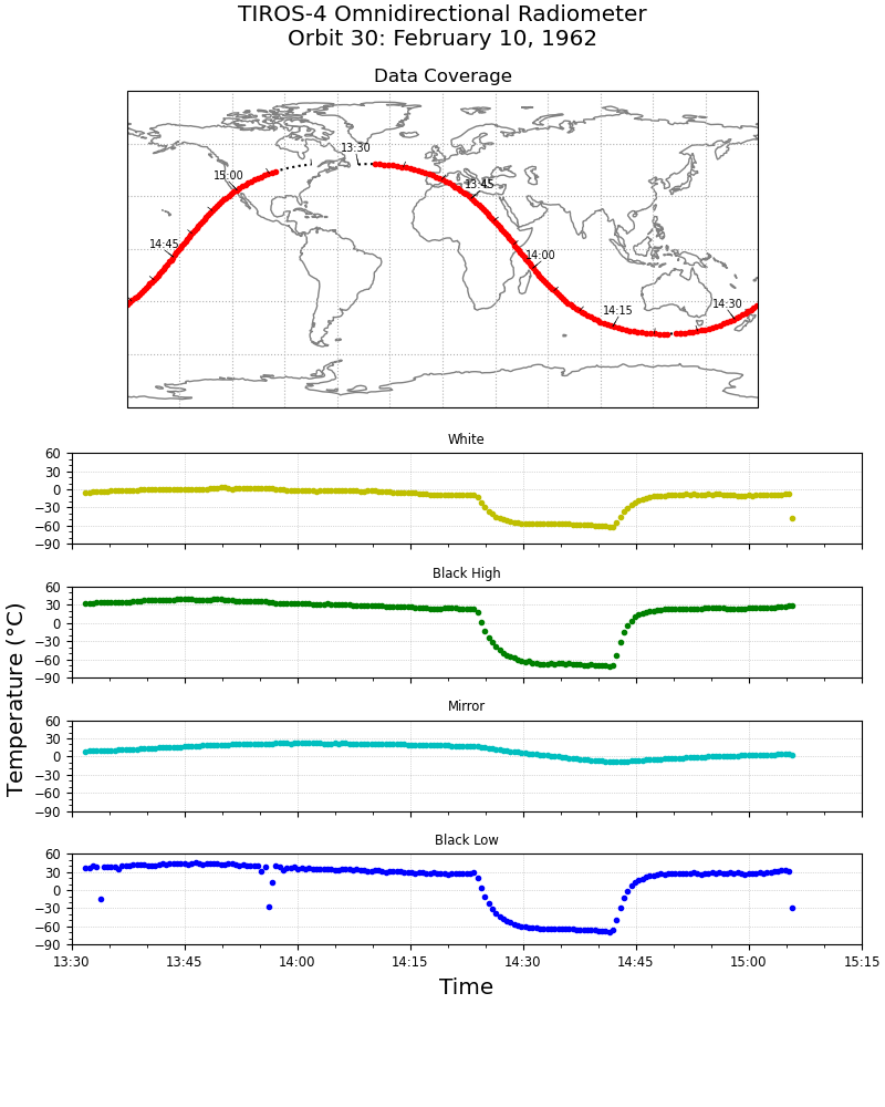
Get a related visualizationPNG
TIROS-4 L1 ORT data showing data coverage and sensor temperatures from the...
-
Download this dataset through a directory mapHTML
Access the data via HTTPS.
-
Download this dataset through Earthdata SearchHTML
Use the Earthdata Search Client to find and retrieve data sets across...
-
View this dataset's read me documentPDF
README Document
-
View documentation related to this datasetHTML
TIROS Inventory
-
Landing PageLanding Page
Dates
| Metadata Created Date | February 22, 2025 |
|---|---|
| Metadata Updated Date | February 22, 2025 |
Metadata Source
- Data.json Data.json Metadata
Harvested from nasa test json
Additional Metadata
| Resource Type | Dataset |
|---|---|
| Metadata Created Date | February 22, 2025 |
| Metadata Updated Date | February 22, 2025 |
| Publisher | NASA/GSFC/SED/ESD/GCDC/GESDISC |
| Maintainer | |
| Identifier | C2152905392-GES_DISC |
| Data First Published | 2021-08-13 |
| Language | en-US |
| Data Last Modified | 2025-02-19 |
| Category | TIROS, geospatial |
| Public Access Level | public |
| Bureau Code | 026:00 |
| Metadata Context | https://project-open-data.cio.gov/v1.1/schema/catalog.jsonld |
| Schema Version | https://project-open-data.cio.gov/v1.1/schema |
| Catalog Describedby | https://project-open-data.cio.gov/v1.1/schema/catalog.json |
| Harvest Object Id | 6e941295-d774-4bac-b5da-6c0f799c55e5 |
| Harvest Source Id | a73e0c30-4684-40ef-908e-d22e9e9e5f86 |
| Harvest Source Title | nasa test json |
| Homepage URL | https://doi.org/10.5067/EGCSHHHVLJKT |
| Metadata Type | geospatial |
| Old Spatial | -180.0 -82.0 180.0 82.0 |
| Program Code | 026:001 |
| Source Datajson Identifier | True |
| Source Hash | a4d2a026fca6d3c3ae6a8d512af90c9536fa60fd4da4a7684a96bd5d7674a228 |
| Source Schema Version | 1.1 |
| Spatial | |
| Temporal | 1962-02-08T00:00:00Z/1962-06-28T23:59:59.999Z |
Didn't find what you're looking for? Suggest a dataset here.