

RSS SSMIS OCEAN PRODUCT GRIDS MONTHLY AVERAGE FROM DMSP F16 NETCDF V7
Access & Use Information
Downloads & Resources
-
Google Scholar search resultsHTML
Search results for publications that cite this dataset by its DOI.
-
Download this datasetHTML
Files may be downloaded directly to your workstation from this link
-
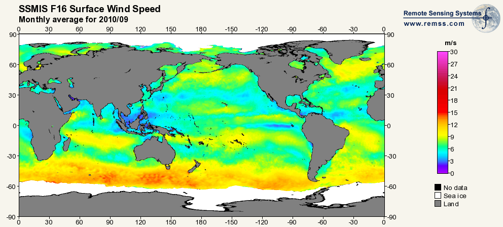
Get a related visualizationPNG
Sample browse image
-
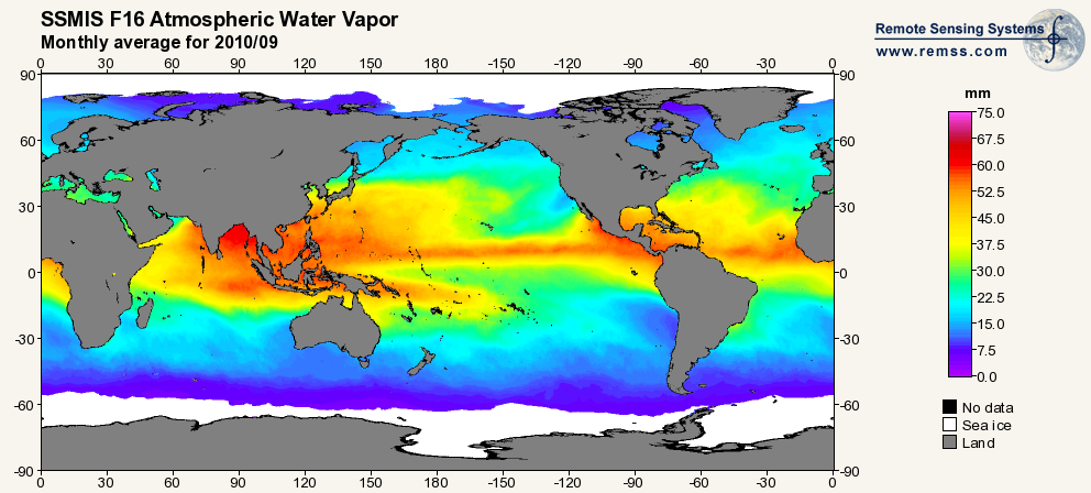
Get a related visualizationPNG
Sample browse image
-
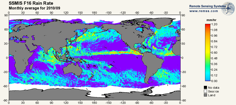
Get a related visualizationPNG
Sample browse image
-
Get a related visualizationPNG
Sample browse image
-
View documentation related to this datasetHTML
GHRC at UAH - SSM/I and SSMIS Data in NetCDF User's Guide
-
View information related to this datasetHTML
Digital Object Identifier for a collection of related datasets
-
View documentation related to this datasetHTML
The guide document contains detailed information about the dataset
-
View the primary investigator's documentation...PDF
A Well Calibrated Ocean Algorithm for SSM/I
-
View the primary investigator's documentation...PDF
SSM/I Rain Retrievals Within an Unified All-Weather Ocean Algorithm
-
View the primary investigator's documentation...PDF
Description of Remote Sensing Systems Version-7 Geophysical Retrievals
-
Use OPeNDAP to access the dataset's dataHTML
OPeNDAP server dataset access
-
View the documentation for this dataset's algorithmsPDF
AMSR Ocean Algorithm documentation supplement
-
View the documentation for this dataset's algorithmsPDF
SSM/I Version-7 Calibration Report
-
View the documentation for this dataset's algorithmsPDF
AMSR Ocean Algorithm documentation
-
Downloadable software applicationsHTML
netCDF read software
-
Get a related visualizationHTML
N/A
-
View documentation related to this datasetHTML
Instructions for citing GHRC data
-
Landing PageLanding Page
Dates
| Metadata Created Date | February 22, 2025 |
|---|---|
| Metadata Updated Date | February 22, 2025 |
Metadata Source
- Data.json Data.json Metadata
Harvested from nasa test json
Additional Metadata
| Resource Type | Dataset |
|---|---|
| Metadata Created Date | February 22, 2025 |
| Metadata Updated Date | February 22, 2025 |
| Publisher | NASA/MSFC/GHRC |
| Maintainer | |
| Identifier | C1996546916-GHRC_DAAC |
| Data First Published | 2012-10-01 |
| Language | en-US |
| Data Last Modified | 2025-02-19 |
| Category | DISCOVER, geospatial |
| Public Access Level | public |
| Bureau Code | 026:00 |
| Metadata Context | https://project-open-data.cio.gov/v1.1/schema/catalog.jsonld |
| Schema Version | https://project-open-data.cio.gov/v1.1/schema |
| Catalog Describedby | https://project-open-data.cio.gov/v1.1/schema/catalog.json |
| Harvest Object Id | 868c872f-7d78-49f8-9134-60dcb2ae3df5 |
| Harvest Source Id | a73e0c30-4684-40ef-908e-d22e9e9e5f86 |
| Harvest Source Title | nasa test json |
| Homepage URL | https://doi.org/10.5067/MEASURES/DMSP-F16/SSMIS/DATA304 |
| Metadata Type | geospatial |
| Old Spatial | -180.0 -90.0 180.0 90.0 |
| Program Code | 026:001 |
| Source Datajson Identifier | True |
| Source Hash | 01a5629bb924d44d488b8edd1fcf45fdb197ad56e9f03ce0a1c67e80ff4a03a8 |
| Source Schema Version | 1.1 |
| Spatial | |
| Temporal | 2003-10-01T00:00:00Z/2022-05-03T00:00:00Z |
Didn't find what you're looking for? Suggest a dataset here.