

OMPS/NPP PCA SO2 Total Column 1-Orbit L2 Swath 50x50km V2 (OMPS_NPP_NMSO2_PCA_L2) at GES DISC
Access & Use Information
Public: This dataset is intended for public access and use.
Non-Federal: This dataset is covered by different Terms of Use than Data.gov.
License: No license information was provided.
Downloads & Resources
-
Google Scholar search resultsHTML
Search results for publications that cite this dataset by its DOI.
-
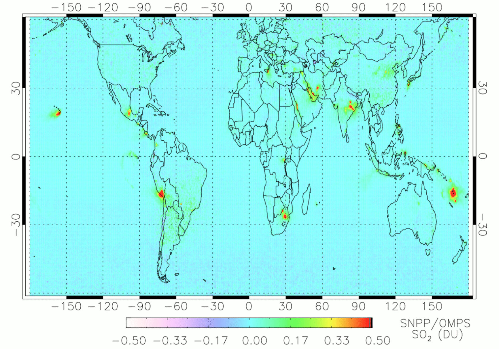
Get a related visualizationPNG
Annual mean SO2 vertical column densities (VCDs) in Dobson Units (DU, 1 DU =...
-
This dataset's landing pageHTML
Access the dataset landing page from the GES DISC website.
-
Download this dataset through a directory mapHTML
Access the data via HTTP
-
Use OPeNDAP to access the dataset's dataHTML
Access the data via the OPeNDAP protocol.
-
Download this dataset through Earthdata SearchHTML
Use the Earthdata Search to find and retrieve data sets across multiple data...
-
View the primary investigator's documentation...HTML
Global Sulfur Dioxide Monitoring Home Page
-
View this dataset's read me documentPDF
README document
-
Landing PageLanding Page
References
| https://doi.org/10.5194/amt-10-1495-2017 |
| https://doi.org/10.5194/amt-10-445-2017 |
| https://doi.org/10.1002/2013GL058134 |
| https://doi.org/10.5194/amt-2020-186 |
Dates
| Metadata Created Date | February 22, 2025 |
|---|---|
| Metadata Updated Date | February 22, 2025 |
Metadata Source
- Data.json Data.json Metadata
Harvested from nasa test json
Additional Metadata
| Resource Type | Dataset |
|---|---|
| Metadata Created Date | February 22, 2025 |
| Metadata Updated Date | February 22, 2025 |
| Publisher | NASA/GSFC/SED/ESD/GCDC/GESDISC |
| Maintainer | |
| Identifier | C1917909223-GES_DISC |
| Data First Published | 2020-07-29 |
| Language | en-US |
| Data Last Modified | 2025-02-19 |
| Category | MEaSUREs, geospatial |
| Public Access Level | public |
| Bureau Code | 026:00 |
| Metadata Context | https://project-open-data.cio.gov/v1.1/schema/catalog.jsonld |
| Schema Version | https://project-open-data.cio.gov/v1.1/schema |
| Catalog Describedby | https://project-open-data.cio.gov/v1.1/schema/catalog.json |
| Harvest Object Id | c752bd39-c26d-46f5-a5b6-2752c5185980 |
| Harvest Source Id | a73e0c30-4684-40ef-908e-d22e9e9e5f86 |
| Harvest Source Title | nasa test json |
| Homepage URL | https://doi.org/10.5067/MEASURES/SO2/DATA205 |
| Metadata Type | geospatial |
| Old Spatial | -180.0 -90.0 180.0 90.0 |
| Program Code | 026:001 |
| Related Documents | https://doi.org/10.5194/amt-10-1495-2017, https://doi.org/10.5194/amt-10-445-2017, https://doi.org/10.1002/2013GL058134, https://doi.org/10.5194/amt-2020-186 |
| Source Datajson Identifier | True |
| Source Hash | e74101a0c32aa11d1bd5142842c1a930a2036bc3b7081d926d1a50a56ffd13f3 |
| Source Schema Version | 1.1 |
| Spatial | |
| Temporal | 2012-01-26T21:52:00Z/2022-01-17T00:00:00Z |
Didn't find what you're looking for? Suggest a dataset here.