

OMI/Aura TOMS-Like Ozone, Aerosol Index, Cloud Radiance Fraction L3 1 day 1 degree x 1 degree V3 (OMTO3d) at GES DISC
Access & Use Information
Downloads & Resources
-
Google Scholar search resultsHTML
Search results for publications that cite this dataset by its DOI.
-
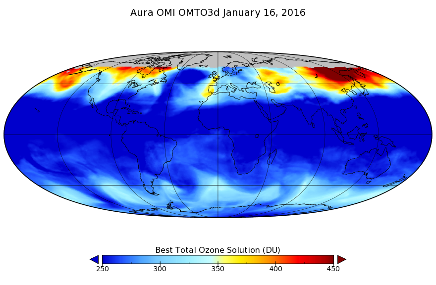
Get a related visualizationPNG
OMTO3d_003.png
-
This dataset's landing pageHTML
Access the dataset landing page from the GES DISC website.
-
Download this dataset through a directory mapHTML
Access the data via HTTPS.
-
Get a related visualization through GIOVANNIHTML
The GES-DISC Interactive Online Visualization ANd aNalysis Interface...
-
Download this dataset through Earthdata SearchHTML
Use the Earthdata Search to find and retrieve data sets across multiple data...
-
Use OPeNDAP to access the dataset's dataHTML
Access the data via the OPeNDAP protocol.
-
View this dataset's read me documentDOC
README Document
-
View this dataset's read me documentPDF
OMI Data User's Guide
-
View the primary investigator's documentation...PDF
File Specification Document
-
The dataset's project home pageHTML
Aura Project Home Page
-
The dataset's project home pageHTML
OMI KNMI Home Page
-
View this dataset's publicationsHTML
-
Use Web Map Service (WMS) to download the...HTML
WEB MAP SERVICE (WMS) GetCapabilities operation
-
Use Web Map Service (WMS) to download the...HTML
Get map from the WMS server for OMTO3d:ColumnAmountO3
-
Use Web Map Service (WMS) to download the...HTML
Get map from the WMS server for OMTO3d:UVAerosolIndex
-
Use Web Map Service (WMS) to download the...HTML
Get map from the WMS server for OMTO3d:RadiativeCloudFraction
-
Use Web Coverage Service (WCS) to download the...HTML
The GetCapabilities operations
-
Use Web Coverage Service (WCS) to download the...HTML
The describeCoverage operations
-
Use Web Coverage Service (WCS) to download the...HTML
Get data from the WCS server for OMTO3d:ColumnAmountO3
-
Use Web Coverage Service (WCS) to download the...HTML
Get data from the WCS server for OMTO3d:RadiativeCloudFraction
-
Use Web Coverage Service (WCS) to download the...HTML
Get data from the WCS server for OMTO3d:UVAerosolIndex
-
Landing PageLanding Page
References
| https://doi.org/10.1109/TGRS.2006.869987 |
| https://doi.org/10.1109/TGRS.2006.872935 |
| https://doi.org/10.1117/12.627013 |
Dates
| Metadata Created Date | February 22, 2025 |
|---|---|
| Metadata Updated Date | February 22, 2025 |
Metadata Source
- Data.json Data.json Metadata
Harvested from nasa test json
Additional Metadata
| Resource Type | Dataset |
|---|---|
| Metadata Created Date | February 22, 2025 |
| Metadata Updated Date | February 22, 2025 |
| Publisher | NASA/GSFC/SED/ESD/GCDC/GESDISC |
| Maintainer | |
| Identifier | C1266136070-GES_DISC |
| Data First Published | 2004-10-01 |
| Language | en-US |
| Data Last Modified | 2025-02-19 |
| Category | Aura, geospatial |
| Public Access Level | public |
| Bureau Code | 026:00 |
| Metadata Context | https://project-open-data.cio.gov/v1.1/schema/catalog.jsonld |
| Schema Version | https://project-open-data.cio.gov/v1.1/schema |
| Catalog Describedby | https://project-open-data.cio.gov/v1.1/schema/catalog.json |
| Harvest Object Id | 8024632d-78f4-48f4-ad91-9f137410280b |
| Harvest Source Id | a73e0c30-4684-40ef-908e-d22e9e9e5f86 |
| Harvest Source Title | nasa test json |
| Homepage URL | https://doi.org/10.5067/Aura/OMI/DATA3001 |
| Metadata Type | geospatial |
| Old Spatial | -180.0 -90.0 180.0 90.0 |
| Program Code | 026:001 |
| Related Documents | https://doi.org/10.1109/TGRS.2006.869987, https://doi.org/10.1109/TGRS.2006.872935, https://doi.org/10.1117/12.627013 |
| Source Datajson Identifier | True |
| Source Hash | b15d4fb6e19e2befad3496473f2e697f1f0446c1d21284696527280e8313e85b |
| Source Schema Version | 1.1 |
| Spatial | |
| Temporal | 2004-10-01T00:00:00Z/2022-01-17T00:00:00Z |
Didn't find what you're looking for? Suggest a dataset here.