

MODIS-based GPP, PAR, fC4, and SANIRv estimates from SLOPE for CONUS, 2000-2019
Access & Use Information
Public: This dataset is intended for public access and use.
Non-Federal: This dataset is covered by different Terms of Use than Data.gov.
License: No license information was provided.
Downloads & Resources
-
Google Scholar search resultsHTML
Search results for publications that cite this dataset by its DOI.
-
Download this datasetHTML
This link allows direct data access via Earthdata login
-
View documentation related to this datasetHTML
ORNL DAAC Data Set Documentation
-
This dataset's landing pageHTML
Data set Landing Page DOI URL
-
View documentation related to this datasetZIP
MODIS-based GPP, PAR, fC4, and SANIRv estimates from SLOPE for CONUS,...
-
View documentation related to this datasetPDF
MODIS-based GPP, PAR, fC4, and SANIRv estimates from SLOPE for CONUS,...
-
Get a related visualizationPNG
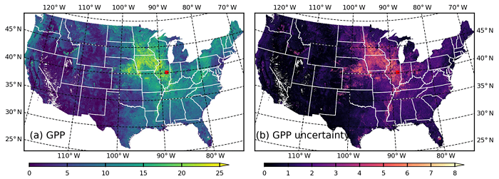
Spatial distribution of (a) GPP (gC m2/d) and (b) GPP uncertainty (gC m2/d)...
-
Landing PageLanding Page
Dates
| Metadata Created Date | February 21, 2025 |
|---|---|
| Metadata Updated Date | February 21, 2025 |
Metadata Source
- Data.json Data.json Metadata
Harvested from nasa test json
Additional Metadata
| Resource Type | Dataset |
|---|---|
| Metadata Created Date | February 21, 2025 |
| Metadata Updated Date | February 21, 2025 |
| Publisher | ORNL_DAAC |
| Maintainer | |
| Identifier | C2266194621-ORNL_CLOUD |
| Data First Published | 2021-11-13 |
| Language | en-US |
| Data Last Modified | 2025-02-19 |
| Category | CMS, geospatial |
| Public Access Level | public |
| Bureau Code | 026:00 |
| Metadata Context | https://project-open-data.cio.gov/v1.1/schema/catalog.jsonld |
| Schema Version | https://project-open-data.cio.gov/v1.1/schema |
| Catalog Describedby | https://project-open-data.cio.gov/v1.1/schema/catalog.json |
| Harvest Object Id | d9cb33d2-81f0-4b88-b062-35c79bdb8400 |
| Harvest Source Id | a73e0c30-4684-40ef-908e-d22e9e9e5f86 |
| Harvest Source Title | nasa test json |
| Homepage URL | https://doi.org/10.3334/ORNLDAAC/1786 |
| Metadata Type | geospatial |
| Old Spatial | -155.57 19.99 -52.22 50.01 |
| Program Code | 026:001 |
| Source Datajson Identifier | True |
| Source Hash | b0c5b44d30ab705a5a41b97161717e18431149d03730febd5ce3bdd8492e1e67 |
| Source Schema Version | 1.1 |
| Spatial | |
| Temporal | 2000-01-01T00:00:00Z/2020-01-01T23:59:59Z |
Didn't find what you're looking for? Suggest a dataset here.