

MERRA-2 statM_2d_pct_Nx: 2d, Single-Level, Monthly Percentiles based on 1991-2020 V2 (M2SMNXPCT) at GES DISC
Access & Use Information
Downloads & Resources
-
Google Scholar search resultsHTML
Search results for publications that cite this dataset by its DOI.
-
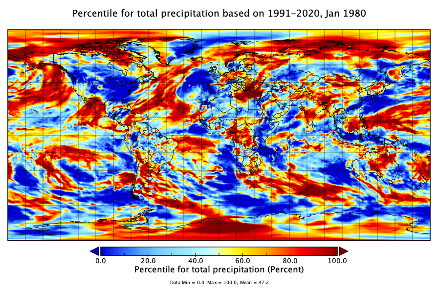
Get a related visualizationPNG
M2SMNXPCT sample image: Percentile for total precipitation (PRECTOT), Jan 1980.
-
View this dataset's how-to documentationHTML
Documents with exmaple on how to read and plot MERRA-2 data.
-
View the primary investigator's documentation...PDF
File Specification Document
-
This dataset's landing pageHTML
Access the dataset landing page from the GES DISC website.
-
Download this dataset through a directory mapHTML
Access the data via HTTPS.
-
Download this dataset through Earthdata SearchHTML
Use the Earthdata Search to find and retrieve data sets across multiple data...
-
Use OPeNDAP to access the dataset's dataHTML
Access the data via the OPeNDAP protocol.
-
The dataset's project home pageHTML
The NASA GMAO MERRA-2 Data Documentation and FAQs
-
View this dataset's read me documentPDF
RREADME Document
-
View documentation related to this datasetHTML
MERRA-2 Data Access – Quick Start Guide
-
View an important notice for this datasetHTML
Records of MERRA-2 Data Reprocessing and Service Changes
-
View documentation related to this datasetHTML
FAQs about MERRA-2 data access
-
Landing PageLanding Page
References
| https://doi.org/10.1175/JCLI-D-16-0758.1 |
Dates
| Metadata Created Date | February 22, 2025 |
|---|---|
| Metadata Updated Date | February 22, 2025 |
Metadata Source
- Data.json Data.json Metadata
Harvested from nasa test json
Additional Metadata
| Resource Type | Dataset |
|---|---|
| Metadata Created Date | February 22, 2025 |
| Metadata Updated Date | February 22, 2025 |
| Publisher | NASA/GSFC/SED/ESD/GCDC/GESDISC |
| Maintainer | |
| Identifier | C2531963252-GES_DISC |
| Data First Published | 2022-11-01 |
| Language | en-US |
| Data Last Modified | 2025-02-19 |
| Category | MERRA-2, geospatial |
| Public Access Level | public |
| Bureau Code | 026:00 |
| Metadata Context | https://project-open-data.cio.gov/v1.1/schema/catalog.jsonld |
| Schema Version | https://project-open-data.cio.gov/v1.1/schema |
| Catalog Describedby | https://project-open-data.cio.gov/v1.1/schema/catalog.json |
| Harvest Object Id | 6f27eed7-6129-4fc6-9df4-086acc2a009a |
| Harvest Source Id | a73e0c30-4684-40ef-908e-d22e9e9e5f86 |
| Harvest Source Title | nasa test json |
| Homepage URL | https://doi.org/10.5067/FM4HEB84DL8C |
| Metadata Type | geospatial |
| Old Spatial | -180.0 -90.0 180.0 90.0 |
| Program Code | 026:001 |
| Related Documents | https://doi.org/10.1175/JCLI-D-16-0758.1 |
| Source Datajson Identifier | True |
| Source Hash | c08a73ed6d2fc8aa9c277db96f8e07ba8149c8ef407dccacf79a9e74b713a308 |
| Source Schema Version | 1.1 |
| Spatial | |
| Temporal | 1980-01-01T00:00:00Z/2023-02-28T00:00:00Z |
Didn't find what you're looking for? Suggest a dataset here.