

Longwave-infrared spectral imagery in support of COMEX, 2014
Access & Use Information
Downloads & Resources
-
Google Scholar search resultsHTML
Search results for publications that cite this dataset by its DOI.
-
Download this datasetHTML
This link allows direct data access via Earthdata login
-
View documentation related to this datasetHTML
ORNL DAAC Data Set Documentation
-
This dataset's landing pageHTML
Data set Landing Page DOI URL
-
View documentation related to this datasetPDF
Longwave-infrared spectral imagery in support of COMEX, 2014:...
-
View documentation related to this datasetPDF
Longwave-infrared spectral imagery in support of COMEX, 2014:...
-
View documentation related to this datasetPDF
Longwave-infrared spectral imagery in support of COMEX, 2014:...
-
View documentation related to this datasetPDF
Longwave-infrared spectral imagery in support of COMEX, 2014:...
-
View documentation related to this datasetPDF
Longwave-infrared spectral imagery in support of COMEX, 2014:...
-
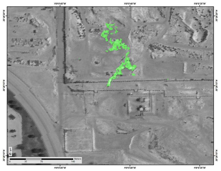
Get a related visualizationJPEG
Methane detection signal (green) of pump jack leak at the Kern River oil...
-
The dataset's project home pageHTML
ESA COMEX Campaign Page
-
Landing PageLanding Page
Dates
| Metadata Created Date | February 22, 2025 |
|---|---|
| Metadata Updated Date | February 22, 2025 |
Metadata Source
- Data.json Data.json Metadata
Harvested from nasa test json
Additional Metadata
| Resource Type | Dataset |
|---|---|
| Metadata Created Date | February 22, 2025 |
| Metadata Updated Date | February 22, 2025 |
| Publisher | ORNL_DAAC |
| Maintainer | |
| Identifier | C3134262949-ORNL_CLOUD |
| Data First Published | 2024-06-26 |
| Language | en-US |
| Data Last Modified | 2025-02-19 |
| Category | COMEX, geospatial |
| Public Access Level | public |
| Bureau Code | 026:00 |
| Metadata Context | https://project-open-data.cio.gov/v1.1/schema/catalog.jsonld |
| Schema Version | https://project-open-data.cio.gov/v1.1/schema |
| Catalog Describedby | https://project-open-data.cio.gov/v1.1/schema/catalog.json |
| Harvest Object Id | 073fe2fc-e0f1-499c-a3f3-1b2955427b62 |
| Harvest Source Id | a73e0c30-4684-40ef-908e-d22e9e9e5f86 |
| Harvest Source Title | nasa test json |
| Homepage URL | https://doi.org/10.3334/ORNLDAAC/2331 |
| Metadata Type | geospatial |
| Old Spatial | -119.94 33.89 -117.45 35.5 |
| Program Code | 026:001 |
| Source Datajson Identifier | True |
| Source Hash | 2ee21a8d565f754e5af07cf48fba827fe3bac5c77579582dff0c90831d4f3d0a |
| Source Schema Version | 1.1 |
| Spatial | |
| Temporal | 2014-07-22T22:34:31Z/2014-07-25T18:46:25Z |
Didn't find what you're looking for? Suggest a dataset here.