

LIS/OTD 0.5 Degree High Resolution Annual Climatology (HRAC) V2.3.2015
Access & Use Information
Downloads & Resources
-
Google Scholar search resultsHTML
Search results for publications that cite this dataset by its DOI.
-
Download this datasetHTML
Files may be downloaded directly to your workstation from this link
-
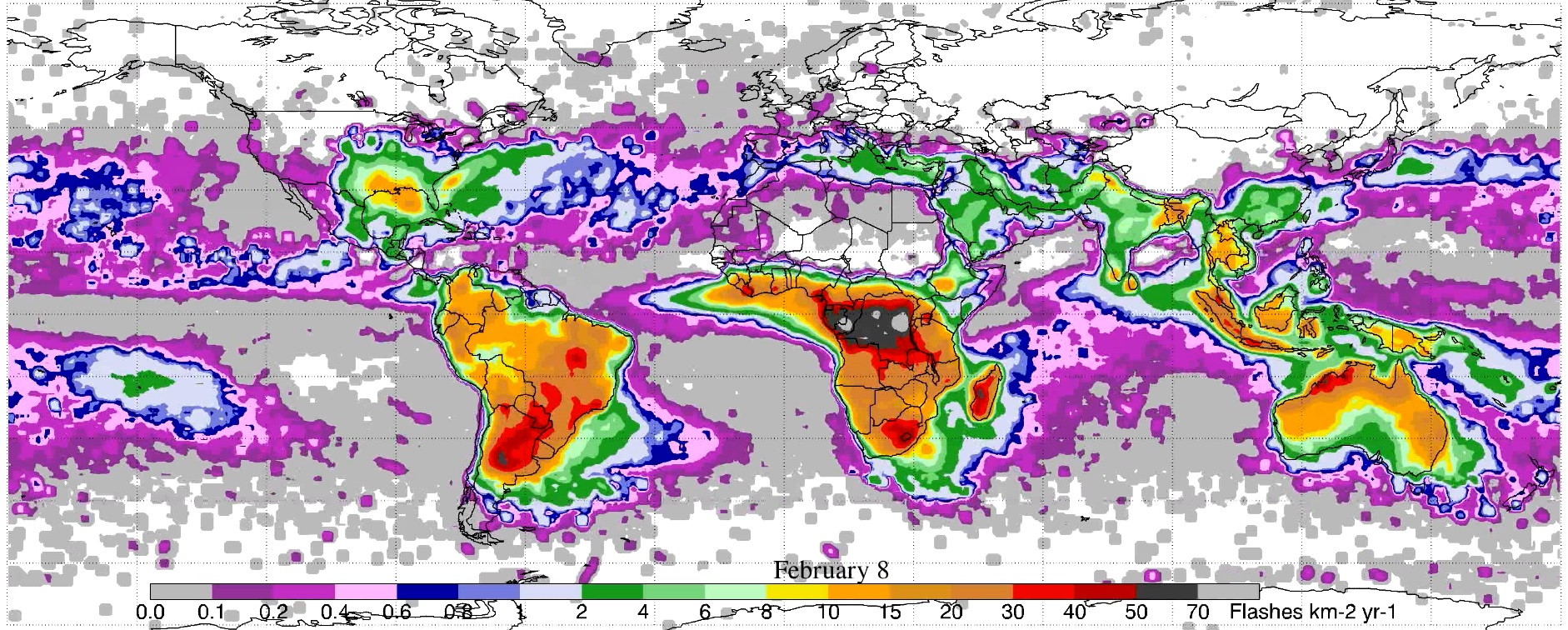
Get a related visualizationJPEG
Browse Sample
-
View documentation related to this datasetPDF
The 13 years of TRMM Lightning Imaging Sensor: From individual flash...
-
View information related to this datasetHTML
Digital Object Identifier for a collection of related datasets
-
View documentation related to this datasetPDF
LIS/OTD Climatology Dataset Collection User Guide
-
View the primary investigator's documentation...DOC
Products in LIS-OTD gridded climatology files
-
View this dataset's publicationsHTML
Global frequency and distribution of lightning as observed from space by the...
-
View the documentation for this dataset's algorithmsHTML
Gridded lightning climatology from TRMM-LIS and OTD: Dataset description
-
Downloadable software applicationsHTML
Read SDS Arrays From an A HDF file
-
Downloadable software applicationsHTML
Read an SDS grid from the LIS/OTD HDF climatology files
-
The dataset's project home pageHTML
Lightning Imaging Sensor (LIS) Overview
-
Get a related visualizationHTML
N/A
-
View documentation related to this datasetHTML
Instructions for citing GHRC data
-
Landing PageLanding Page
Dates
| Metadata Created Date | February 21, 2025 |
|---|---|
| Metadata Updated Date | February 21, 2025 |
Metadata Source
- Data.json Data.json Metadata
Harvested from nasa test json
Additional Metadata
| Resource Type | Dataset |
|---|---|
| Metadata Created Date | February 21, 2025 |
| Metadata Updated Date | February 21, 2025 |
| Publisher | NASA/MSFC/GHRC |
| Maintainer | |
| Identifier | C1995863067-GHRC_DAAC |
| Data First Published | 2006-09-13 |
| Language | en-US |
| Data Last Modified | 2025-02-19 |
| Category | LIS, geospatial |
| Public Access Level | public |
| Bureau Code | 026:00 |
| Metadata Context | https://project-open-data.cio.gov/v1.1/schema/catalog.jsonld |
| Schema Version | https://project-open-data.cio.gov/v1.1/schema |
| Catalog Describedby | https://project-open-data.cio.gov/v1.1/schema/catalog.json |
| Harvest Object Id | 4f67565d-5060-4d85-a863-878c4e7c5b1e |
| Harvest Source Id | a73e0c30-4684-40ef-908e-d22e9e9e5f86 |
| Harvest Source Title | nasa test json |
| Homepage URL | https://doi.org/10.5067/LIS/LIS-OTD/DATA301 |
| Metadata Type | geospatial |
| Old Spatial | -179.75 -89.75 179.75 89.75 |
| Program Code | 026:001 |
| Source Datajson Identifier | True |
| Source Hash | c461ed37a5c5fa8768eeed72da9f63de242fc3497b6bab22fc4dccd6b3bdae38 |
| Source Schema Version | 1.1 |
| Spatial | |
| Temporal | 1995-05-04T00:00:00Z/2014-12-31T23:59:59Z |
Didn't find what you're looking for? Suggest a dataset here.