

LIS 0.1 DEGREE VERY HIGH RESOLUTION GRIDDED LIGHTNING ANNUAL CLIMATOLOGY (VHRAC) V1
Access & Use Information
Downloads & Resources
-
Google Scholar search resultsHTML
Search results for publications that cite this dataset by its DOI.
-
Download this datasetHTML
Files may be downloaded directly to your workstation from this link
-
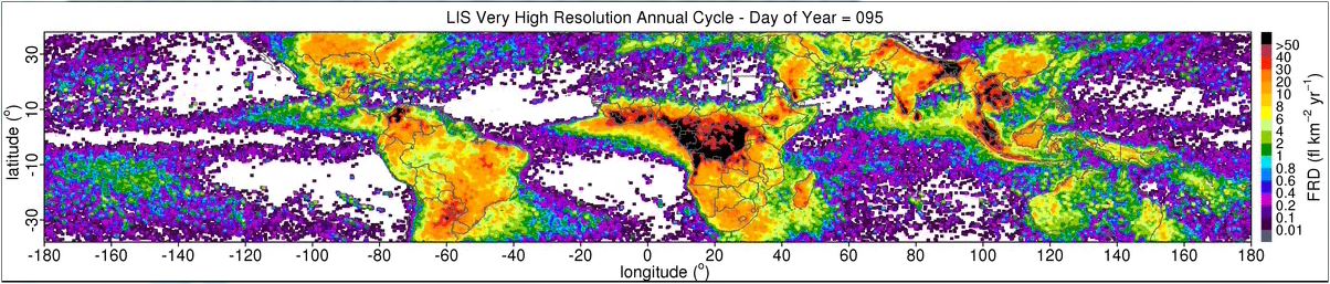
Get a related visualizationJPEG
Sample browse image
-
View information related to this datasetHTML
Collection DOI for set of related datasets
-
View documentation related to this datasetPDF
The guide document contains detailed information about the dataset
-
View the primary investigator's documentation...HTML
Where are the lightning hotspots on Earth?
-
Downloadable software applicationsHTML
LIS Very High Resolution Climatology Data Reader Code
-
The dataset's project home pageHTML
The home page for the project or program which sponsored the dataset
-
Use this dataset in a web based toolHTML
Google Earth Tool
-
View a micro article on this datasetHTML
Highlights from Albrecht et. al's 'Where Are the Lightning Hotspots on...
-
Get a related visualizationHTML
N/A
-
View documentation related to this datasetHTML
Instructions for citing GHRC data
-
Landing PageLanding Page
Dates
| Metadata Created Date | February 22, 2025 |
|---|---|
| Metadata Updated Date | February 22, 2025 |
Metadata Source
- Data.json Data.json Metadata
Harvested from nasa test json
Additional Metadata
| Resource Type | Dataset |
|---|---|
| Metadata Created Date | February 22, 2025 |
| Metadata Updated Date | February 22, 2025 |
| Publisher | NASA/MSFC/GHRC |
| Maintainer | |
| Identifier | C1979882997-GHRC_DAAC |
| Data First Published | 2016-03-02 |
| Language | en-US |
| Data Last Modified | 2025-02-19 |
| Category | LIS, geospatial |
| Public Access Level | public |
| Bureau Code | 026:00 |
| Metadata Context | https://project-open-data.cio.gov/v1.1/schema/catalog.jsonld |
| Schema Version | https://project-open-data.cio.gov/v1.1/schema |
| Catalog Describedby | https://project-open-data.cio.gov/v1.1/schema/catalog.json |
| Harvest Object Id | 800b2466-d65c-4d83-80ca-525f1f6355cd |
| Harvest Source Id | a73e0c30-4684-40ef-908e-d22e9e9e5f86 |
| Harvest Source Title | nasa test json |
| Homepage URL | https://doi.org/10.5067/LIS/LIS/DATA304 |
| Metadata Type | geospatial |
| Old Spatial | -180.0 -38.0 180.0 38.0 |
| Program Code | 026:001 |
| Source Datajson Identifier | True |
| Source Hash | f1a26a232e38414f1a49967b49e64ce5fa0c5bd644556e1266b46f86cf1a76e4 |
| Source Schema Version | 1.1 |
| Spatial | |
| Temporal | 1998-01-01T00:00:00Z/2013-12-31T23:59:59Z |
Didn't find what you're looking for? Suggest a dataset here.