

Hurricane and Severe Storm Sentinel (HS3) Global Modeling and Assimilation Office (GMAO) Dust Aerosol Optical Thickness Imagery V1
Access & Use Information
Downloads & Resources
-
Google Scholar search resultsHTML
Search results for publications that cite this dataset by its DOI.
-
Download this datasetHTML
Files may be downloaded directly to your workstation from this link
-
Get a related visualizationPNG
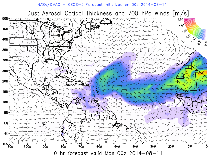
Sample Browse Image
-
View documentation related to this datasetPDF
The GEOS-5 atmospheric general circulation model: Mean climate and...
-
View information related to this datasetHTML
HS3 Collection DOI
-
View information related to this datasetHTML
NASA Hurricane and Severe Storm Sentinel mission
-
View documentation related to this datasetPDF
The guide document contains detailed information about the dataset
-
View this dataset's publicationsHTML
NASA’s Hurricane and Severe Storm Sentinel (HS3) Investigation
-
The dataset's project home pageHTML
HS3 Project Home Page
-
View documentation related to this datasetHTML
Instructions for citing GHRC data
-
Landing PageLanding Page
Dates
| Metadata Created Date | February 22, 2025 |
|---|---|
| Metadata Updated Date | February 22, 2025 |
Metadata Source
- Data.json Data.json Metadata
Harvested from nasa test json
Additional Metadata
| Resource Type | Dataset |
|---|---|
| Metadata Created Date | February 22, 2025 |
| Metadata Updated Date | February 22, 2025 |
| Publisher | NASA/MSFC/GHRC |
| Maintainer | |
| Identifier | C1979863757-GHRC_DAAC |
| Data First Published | 2018-11-07 |
| Language | en-US |
| Data Last Modified | 2025-02-19 |
| Category | HS3, geospatial |
| Public Access Level | public |
| Bureau Code | 026:00 |
| Metadata Context | https://project-open-data.cio.gov/v1.1/schema/catalog.jsonld |
| Schema Version | https://project-open-data.cio.gov/v1.1/schema |
| Catalog Describedby | https://project-open-data.cio.gov/v1.1/schema/catalog.json |
| Harvest Object Id | ad31aa59-4f3b-4c18-bfb5-4603f7b9ddd5 |
| Harvest Source Id | a73e0c30-4684-40ef-908e-d22e9e9e5f86 |
| Harvest Source Title | nasa test json |
| Homepage URL | https://doi.org/10.5067/HS3/GMAO/DATA101 |
| Metadata Type | geospatial |
| Old Spatial | -111.0 -10.0 0.0 50.0 |
| Program Code | 026:001 |
| Source Datajson Identifier | True |
| Source Hash | 6bccd407cd4fd6afc136b87913cac870f8170d4a77685a20e1a19136d9ea1e47 |
| Source Schema Version | 1.1 |
| Spatial | |
| Temporal | 2014-08-11T00:00:00Z/2014-10-05T12:00:00Z |
Didn't find what you're looking for? Suggest a dataset here.