

Hurricane and Severe Storm Sentinel (HS3) Cooperative Institute for Meteorological Satellite Studies (CIMSS) Cloud Top Height V1
Access & Use Information
Public: This dataset is intended for public access and use.
Non-Federal: This dataset is covered by different Terms of Use than Data.gov.
License: No license information was provided.
Downloads & Resources
-
Google Scholar search resultsHTML
Search results for publications that cite this dataset by its DOI.
-
Download this datasetHTML
Files may be downloaded directly to your workstation from this link
-
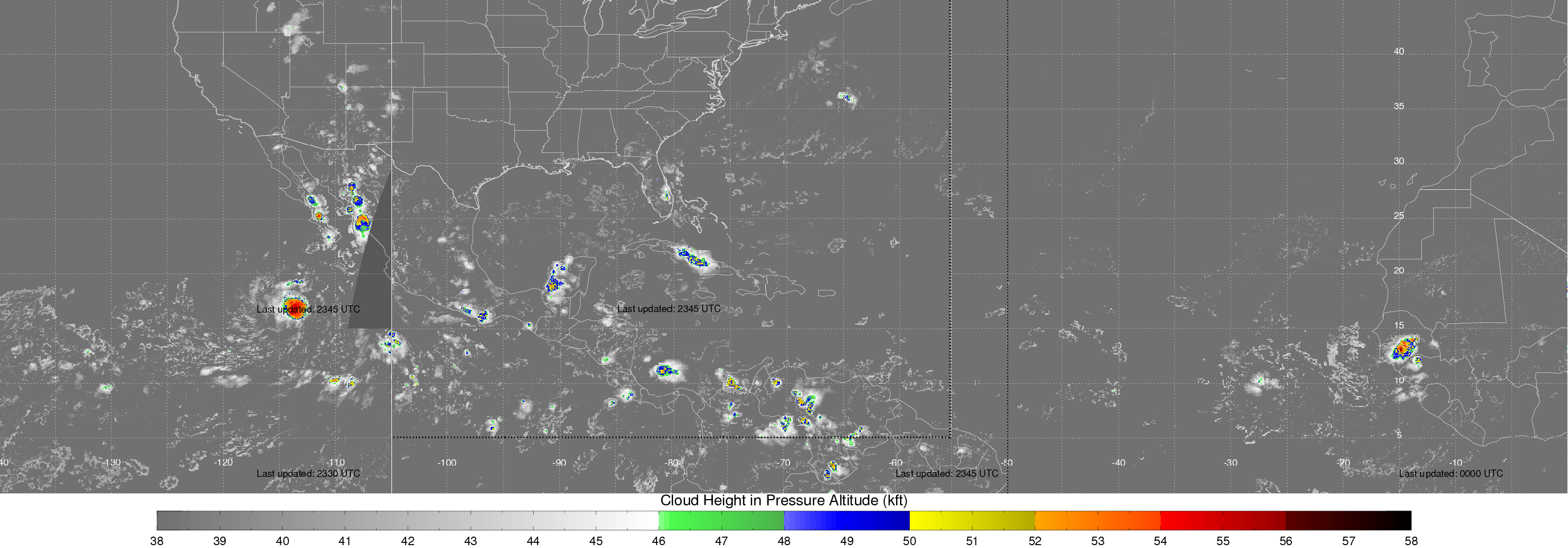
Get a related visualizationPNG
Sample Browse Image
-
View information related to this datasetHTML
HS3 Field Campaign Collection DOI
-
View documentation related to this datasetPDF
The guide document contains detailed information about the dataset
-
View this dataset's publicationsHTML
NASA’s Hurricane and Severe Storm Sentinel (HS3) Investigation
-
View this dataset's algorithm theoretical...PDF
AWG Cloud Height Algorithm (ACHA)
-
The dataset's project home pageHTML
HS3 Project Home Page
-
View documentation related to this datasetHTML
Instructions for citing GHRC data
-
Landing PageLanding Page
Dates
| Metadata Created Date | February 22, 2025 |
|---|---|
| Metadata Updated Date | February 22, 2025 |
Metadata Source
- Data.json Data.json Metadata
Harvested from nasa test json
Additional Metadata
| Resource Type | Dataset |
|---|---|
| Metadata Created Date | February 22, 2025 |
| Metadata Updated Date | February 22, 2025 |
| Publisher | NASA/MSFC/GHRC |
| Maintainer | |
| Identifier | C1983220658-GHRC_DAAC |
| Data First Published | 2018-09-21 |
| Language | en-US |
| Data Last Modified | 2025-02-19 |
| Category | HS3, geospatial |
| Public Access Level | public |
| Bureau Code | 026:00 |
| Metadata Context | https://project-open-data.cio.gov/v1.1/schema/catalog.jsonld |
| Schema Version | https://project-open-data.cio.gov/v1.1/schema |
| Catalog Describedby | https://project-open-data.cio.gov/v1.1/schema/catalog.json |
| Harvest Object Id | e5aefa0a-2c85-4f6c-a3d2-9f250b35a664 |
| Harvest Source Id | a73e0c30-4684-40ef-908e-d22e9e9e5f86 |
| Harvest Source Title | nasa test json |
| Homepage URL | https://doi.org/10.5067/HS3/CIMSS/DATA201 |
| Metadata Type | geospatial |
| Old Spatial | -180.0 12.0 -60.0 52.0 |
| Program Code | 026:001 |
| Source Datajson Identifier | True |
| Source Hash | 91897841e95bff7676063916226ab21fe8e1f8ac4fdbad7cea627ce331d5171c |
| Source Schema Version | 1.1 |
| Spatial | |
| Temporal | 2014-08-14T00:21:00Z/2014-10-03T19:47:00Z |
Didn't find what you're looking for? Suggest a dataset here.