

GPM SAPHIR on MT1 (PRPS) Climate-based Radiometer Precipitation Profiling L3 1 month 0.25 x 0.25 degree V06 (GPM_3PRPSMT1SAPHIR_CLIM) at GES DISC
Access & Use Information
Downloads & Resources
-
Google Scholar search resultsHTML
Search results for publications that cite this dataset by its DOI.
-
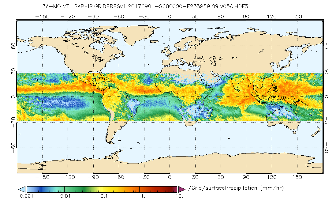
Get a related visualizationPNG
GPM SAPHIR on MT1 (PRPS) Radiometer Precipitation Profiling L3 1 month 0.25 x...
-
This dataset's landing pageHTML
Access the dataset landing page from the GES DISC website.
-
Download this dataset through a directory mapHTML
Access the data via HTTPS
-
Use OPeNDAP to access the dataset's dataHTML
Access the data via the OPeNDAP protocol.
-
Download this dataset through Earthdata SearchHTML
Use the Earthdata Search Client to find and retrieve data sets across...
-
The dataset's project home pageHTML
GPM Project Home Page
-
View this dataset's read me documentPDF
README Document
-
View this dataset's algorithm theoretical...PDF
The PRPS Algorithm Theoretical Base Document
-
View this dataset's algorithm theoretical...HTML
All available GPM Algorithm Theoretical Base Documents
-
View documentation related to this datasetHTML
Instrument Description
-
View this dataset's documented anomaliesHTML
GPM and partner sensors anomalous events
-
Landing PageLanding Page
Dates
| Metadata Created Date | February 22, 2025 |
|---|---|
| Metadata Updated Date | February 22, 2025 |
Metadata Source
- Data.json Data.json Metadata
Harvested from nasa test json
Additional Metadata
| Resource Type | Dataset |
|---|---|
| Metadata Created Date | February 22, 2025 |
| Metadata Updated Date | February 22, 2025 |
| Publisher | NASA/GSFC/SED/ESD/GCDC/GESDISC |
| Maintainer | |
| Identifier | C1596594717-GES_DISC |
| Data First Published | 2019-03-20 |
| Language | en-US |
| Data Last Modified | 2025-02-19 |
| Category | GPM, geospatial |
| Public Access Level | public |
| Bureau Code | 026:00 |
| Metadata Context | https://project-open-data.cio.gov/v1.1/schema/catalog.jsonld |
| Schema Version | https://project-open-data.cio.gov/v1.1/schema |
| Catalog Describedby | https://project-open-data.cio.gov/v1.1/schema/catalog.json |
| Harvest Object Id | 3b64297c-7346-46d1-8023-cfdb6b7b5f0b |
| Harvest Source Id | a73e0c30-4684-40ef-908e-d22e9e9e5f86 |
| Harvest Source Title | nasa test json |
| Homepage URL | https://doi.org/10.5067/GPM/SAPHIR/MT1/PRPSCLIM/3A-MONTH/06 |
| Metadata Type | geospatial |
| Old Spatial | -180.0 -90.0 180.0 90.0 |
| Program Code | 026:001 |
| Source Datajson Identifier | True |
| Source Hash | 0dab9001312758673313a9352a1b15ea65dc42042d9fde1d6e590bd3a3abff0b |
| Source Schema Version | 1.1 |
| Spatial | |
| Temporal | 2011-10-01T00:00:00Z/2021-12-31T23:59:59.999Z |
Didn't find what you're looking for? Suggest a dataset here.