

GPM GROUND VALIDATION MCGILL VERTICAL POINTING X-BAND (VERTIX) RADAR GCPEX V1
Access & Use Information
Downloads & Resources
-
Google Scholar search resultsHTML
Search results for publications that cite this dataset by its DOI.
-
Download this datasetHTML
Files may be downloaded directly to your workstation from this link
-
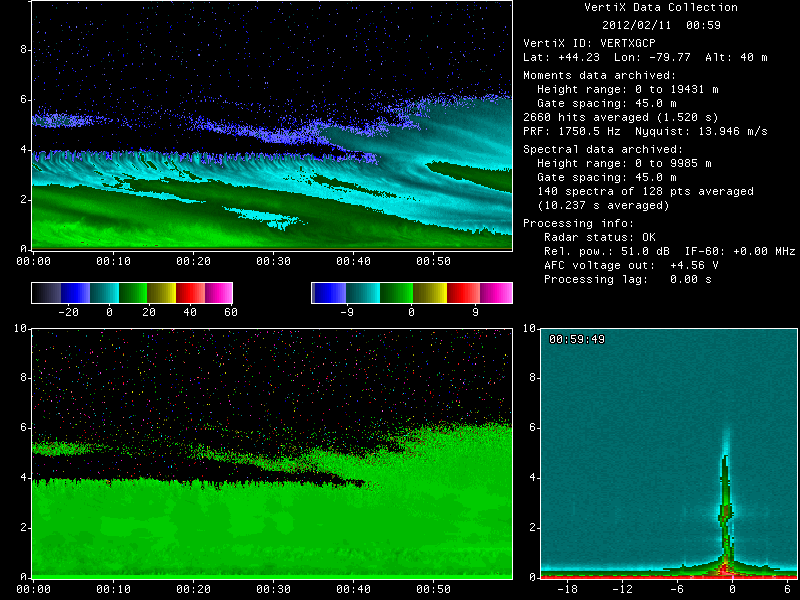
Get a related visualizationGIF
Sample Browse Image
-
View documentation related to this datasetPDF
GPM Cold-season Precipitation Experiment (GCPEx) Science Plan
-
View information related to this datasetHTML
GCPEx Field Campaign Collection DOI
-
View information related to this datasetHTML
GCPEx Field Site
-
View information related to this datasetHTML
McGill X-band radar
-
View information related to this datasetHTML
VertiX - Example: Vertically pointing X-band radar (VertiX)
-
View documentation related to this datasetPDF
The guide document contains detailed information about the dataset
-
View the primary investigator's documentation...HTML
McGill GCPEx VertiX and W-band Radar NetCDF Data Documentation
-
View this dataset's publicationsHTML
Measurements of melting layer attenuation at X-band frequencies
-
View this dataset's publicationsHTML
Global Precipitation Measurement Cold Season Precipitation Experiment...
-
View this dataset's publicationsHTML
Structure and Evolution of a Warm Frontal Precipitation Band during the GPM...
-
View this dataset's publicationsHTML
Observations of supercooled water and secondary ice generation by a...
-
The dataset's project home pageHTML
GCPEx Field Campaign Project Homepage
-
Get a related visualizationHTML
N/A
-
View documentation related to this datasetHTML
Instructions for citing GHRC data
-
Landing PageLanding Page
Dates
| Metadata Created Date | February 22, 2025 |
|---|---|
| Metadata Updated Date | February 22, 2025 |
Metadata Source
- Data.json Data.json Metadata
Harvested from nasa test json
Additional Metadata
| Resource Type | Dataset |
|---|---|
| Metadata Created Date | February 22, 2025 |
| Metadata Updated Date | February 22, 2025 |
| Publisher | NASA/MSFC/GHRC |
| Maintainer | |
| Identifier | C1979830182-GHRC_DAAC |
| Data First Published | 2013-12-17 |
| Language | en-US |
| Data Last Modified | 2025-02-19 |
| Category | GCPEx, geospatial |
| Public Access Level | public |
| Bureau Code | 026:00 |
| Metadata Context | https://project-open-data.cio.gov/v1.1/schema/catalog.jsonld |
| Schema Version | https://project-open-data.cio.gov/v1.1/schema |
| Catalog Describedby | https://project-open-data.cio.gov/v1.1/schema/catalog.json |
| Harvest Object Id | 3424969b-89b5-45eb-99c4-f0aeb7135eae |
| Harvest Source Id | a73e0c30-4684-40ef-908e-d22e9e9e5f86 |
| Harvest Source Title | nasa test json |
| Homepage URL | https://doi.org/10.5067/GPMGV/GCPEX/VERTIX/DATA301 |
| Metadata Type | geospatial |
| Old Spatial | -79.7906 44.2232 -79.7706 44.2432 |
| Program Code | 026:001 |
| Source Datajson Identifier | True |
| Source Hash | b3114b4338f3074085811bfb085955a2b857b20ec964e580454eb037ac2b33e8 |
| Source Schema Version | 1.1 |
| Spatial | |
| Temporal | 2012-01-15T17:19:09Z/2012-02-29T23:59:58Z |
Didn't find what you're looking for? Suggest a dataset here.