

GPM Ground Validation Global Flood Monitoring System (GFMS) Flood Maps IFloodS V1
Access & Use Information
Downloads & Resources
-
Google Scholar search resultsHTML
Search results for publications that cite this dataset by its DOI.
-
Download this datasetHTML
Files may be downloaded directly to your workstation from this link
-
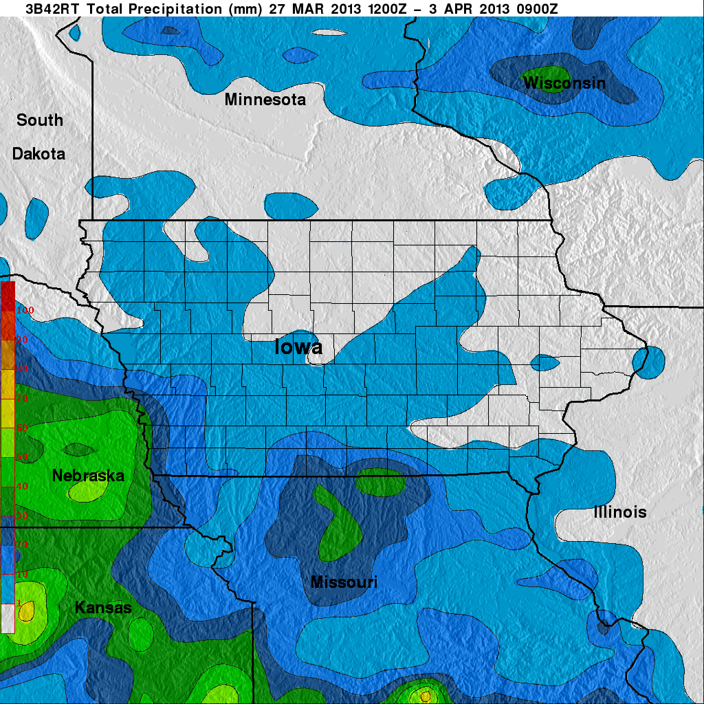
Get a related visualizationJPEG
Sample Browse Image
-
View information related to this datasetHTML
IFloodS Field Campaign Collection DOI
-
View documentation related to this datasetPDF
The guide document contains detailed information about the dataset
-
View this dataset's publicationsHTML
Real-time global flood estimation using satellite-based precipitation and a...
-
View this dataset's publicationsHTML
Evaluation of Global Flood Detection Using Satellite-Based Rainfall and a...
-
View this dataset's publicationsHTML
A new global river network database for macroscale hydrologic modeling
-
View this dataset's publicationsHTML
A Simple hydrologically Based Model of Land Surface Water and Energy Fluxes...
-
View this dataset's publicationsHTML
The TRMM multisatellite precipitation analysis (TMPA): quasi-global,...
-
The dataset's project home pageHTML
GHRC home page for IFloodS field campaign
-
Get a related visualizationHTML
Browse images illustrate the nature and coverage of the data
-
View documentation related to this datasetHTML
Instructions for citing GHRC data
-
Landing PageLanding Page
Dates
| Metadata Created Date | February 22, 2025 |
|---|---|
| Metadata Updated Date | February 22, 2025 |
Metadata Source
- Data.json Data.json Metadata
Harvested from nasa test json
Additional Metadata
| Resource Type | Dataset |
|---|---|
| Metadata Created Date | February 22, 2025 |
| Metadata Updated Date | February 22, 2025 |
| Publisher | NASA/MSFC/GHRC |
| Maintainer | |
| Identifier | C1979816569-GHRC_DAAC |
| Data First Published | 2018-06-22 |
| Language | en-US |
| Data Last Modified | 2025-02-19 |
| Category | IFLOODS, geospatial |
| Public Access Level | public |
| Bureau Code | 026:00 |
| Metadata Context | https://project-open-data.cio.gov/v1.1/schema/catalog.jsonld |
| Schema Version | https://project-open-data.cio.gov/v1.1/schema |
| Catalog Describedby | https://project-open-data.cio.gov/v1.1/schema/catalog.json |
| Harvest Object Id | c34b3f87-9893-4748-8945-73add3638a81 |
| Harvest Source Id | a73e0c30-4684-40ef-908e-d22e9e9e5f86 |
| Harvest Source Title | nasa test json |
| Homepage URL | https://doi.org/10.5067/GPMGV/IFLOODS/TMI/DATA101 |
| Metadata Type | geospatial |
| Old Spatial | -179.875 -49.875 179.875 49.875 |
| Program Code | 026:001 |
| Source Datajson Identifier | True |
| Source Hash | 85e5d86dbde1c65d51b9e33942d2827867f8a1262b0b6c607266b408050c6848 |
| Source Schema Version | 1.1 |
| Spatial | |
| Temporal | 2013-03-26T15:00:00Z/2013-06-30T21:00:00Z |
Didn't find what you're looking for? Suggest a dataset here.