

GOES-R PLT Cloud Radar System (CRS) V1
Access & Use Information
Downloads & Resources
-
Google Scholar search resultsHTML
Search results for publications that cite this dataset by its DOI.
-
Download this datasetHTML
Files may be downloaded directly to your workstation from this link
-
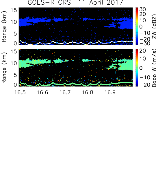
Get a related visualizationPNG
Sample Browse Image
-
View documentation related to this datasetHTML
High Altitude Radar: Cloud Radar System (CRS)
-
View information related to this datasetHTML
NASA Armstrong Fact Sheet: ER-2 High-Altitude Airborne Science Aircraft
-
View documentation related to this datasetPDF
The guide document contains detailed information about the dataset
-
View this dataset's publicationsHTML
Using a multiwavelength suite of microwave instruments to investigate the...
-
View this dataset's publicationsHTML
Ice Cloud Retrievals and Analysis with the Compact Scanning Submillimeter...
-
View this dataset's publicationsHTML
A 94-GHz Cloud Radar System on a NASA High-Altitude ER-2 Aircraft
-
View this dataset's publicationsHTML
Measurements of Ocean Surface Backscattering Using an Airborne 94-GHz Cloud...
-
View this dataset's publicationsHTML
Combined lidar-radar remote sensing: Initial results from CRYSTAL-FACE
-
View this dataset's publicationsHTML
Cirrus cloud optical, microphysical, and radiative properties observed during...
-
View this dataset's publicationsHTML
Retrieving optically thick ice cloud microphysical properties by using...
-
View a micro article on this datasetHTML
GOES-R Post Launch Test (PLT) Field Campaign
-
Get a related visualizationHTML
Browse images illustrate the nature and coverage of the data
-
View documentation related to this datasetHTML
Instructions for citing GHRC data
-
Landing PageLanding Page
Dates
| Metadata Created Date | February 22, 2025 |
|---|---|
| Metadata Updated Date | February 22, 2025 |
Metadata Source
- Data.json Data.json Metadata
Harvested from nasa test json
Additional Metadata
| Resource Type | Dataset |
|---|---|
| Metadata Created Date | February 22, 2025 |
| Metadata Updated Date | February 22, 2025 |
| Publisher | NASA/MSFC/GHRC |
| Maintainer | |
| Identifier | C1995568976-GHRC_DAAC |
| Data First Published | 2019-05-13 |
| Language | en-US |
| Data Last Modified | 2025-02-19 |
| Category | GOES-R PLT, geospatial |
| Public Access Level | public |
| Bureau Code | 026:00 |
| Metadata Context | https://project-open-data.cio.gov/v1.1/schema/catalog.jsonld |
| Schema Version | https://project-open-data.cio.gov/v1.1/schema |
| Catalog Describedby | https://project-open-data.cio.gov/v1.1/schema/catalog.json |
| Harvest Object Id | 056c0c94-7848-4f9a-b0fe-d16c28b4601a |
| Harvest Source Id | a73e0c30-4684-40ef-908e-d22e9e9e5f86 |
| Harvest Source Title | nasa test json |
| Homepage URL | https://doi.org/10.5067/GOESRPLT/CRS/DATA101 |
| Metadata Type | geospatial |
| Old Spatial | -117.184 26.4488 -72.2019 43.5725 |
| Program Code | 026:001 |
| Source Datajson Identifier | True |
| Source Hash | 03e53a8c7feaca45adc7a54ff094cd3cf70e7f7646e334c7a19e528195dfb83f |
| Source Schema Version | 1.1 |
| Spatial | |
| Temporal | 2017-04-11T16:29:39Z/2017-05-17T07:35:23Z |
Didn't find what you're looking for? Suggest a dataset here.