

FLUXNET Research Network Site Characteristics, Investigators, and Bibliography, 2016
Access & Use Information
Downloads & Resources
-
Google Scholar search resultsHTML
Search results for publications that cite this dataset by its DOI.
-
Download this datasetHTML
This link allows direct data access via Earthdata login
-
View documentation related to this datasetHTML
ORNL DAAC Data Set Documentation
-
This dataset's landing pageHTML
Data set Landing Page DOI URL
-
View documentation related to this datasetPNG
fluxnet_Climate.png
-
View documentation related to this datasetPNG
fluxnet_Koppen_3-2016.png
-
View documentation related to this datasetPNG
fluxnet_LAI_3-2016.png
-
View documentation related to this datasetPNG
fluxnet_LAI_3-2016_ShadedPoints.png
-
View documentation related to this datasetPNG
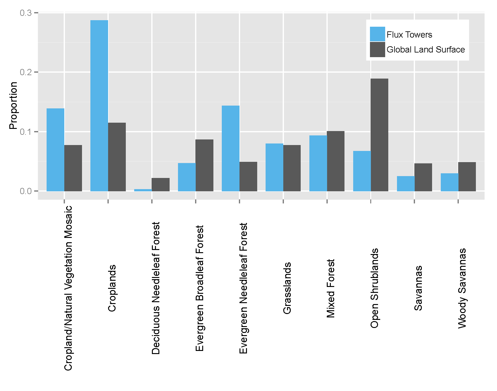
fluxnet_landcover_proportions.png
-
View documentation related to this datasetPNG
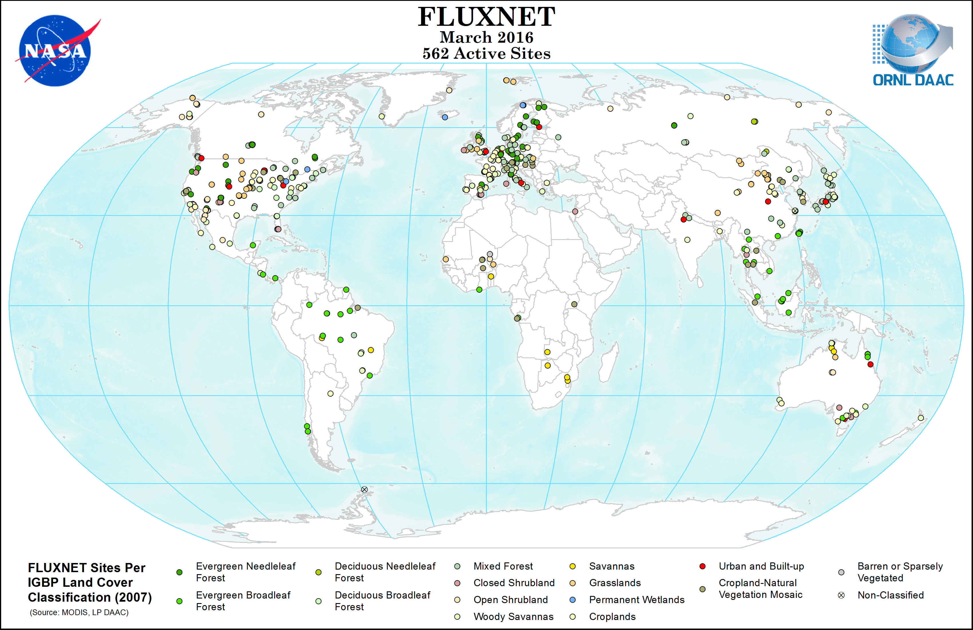
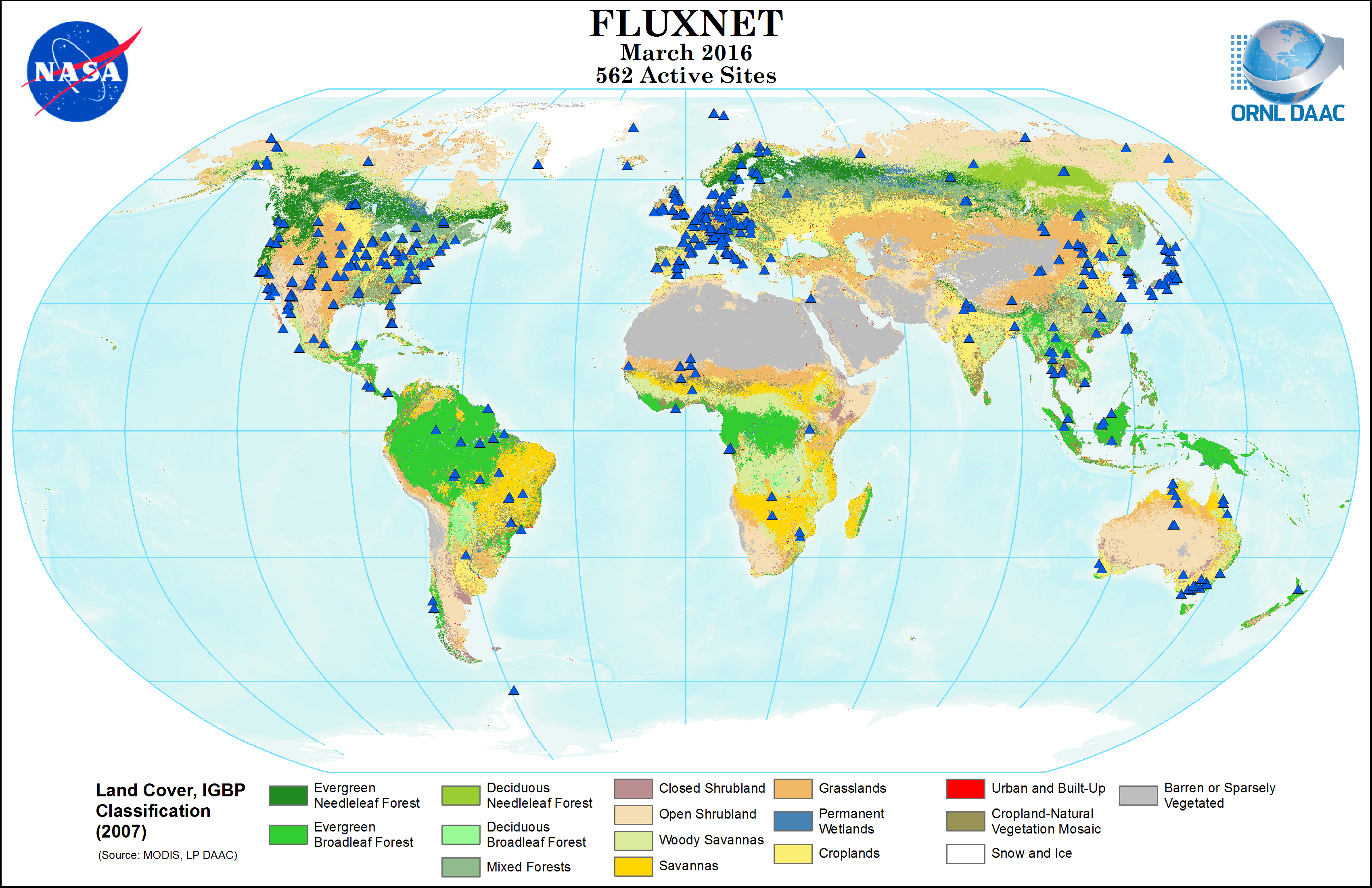
fluxnet_MODIS_IGBP_3-2016.png
-
View documentation related to this datasetPNG
fluxnet_MODIS_IGBP_3-2016_ShadedPoints.png
-
View documentation related to this datasetPNG
fluxnet_Networks_3-2016.png
-
View documentation related to this datasetKML
fluxnet_sites.kmz
-
View documentation related to this datasetPDF
Fluxnet_site_DB.pdf
-
View documentation related to this datasetPNG
Fluxnet_site_DB_Fig1.png
-
View documentation related to this datasetPNG
fluxnet_Temp_Precip_Lat.png
-
View documentation related to this datasetPNG
fluxnet_Topo_3-2016.png
-
View documentation related to this datasetJPEG
fluxnet_tower_sites_201404.jpg
-
View documentation related to this datasetPNG
fluxnet_UMDLandcover_3-2016.png
-
View documentation related to this datasetPNG
fluxnet_UMDLandcover_3-2016_ShadedPoints.png
-
Get a related visualizationPNG
Browse Image
-
Landing PageLanding Page
Dates
| Metadata Created Date | February 22, 2025 |
|---|---|
| Metadata Updated Date | February 22, 2025 |
Metadata Source
- Data.json Data.json Metadata
Harvested from nasa test json
Additional Metadata
| Resource Type | Dataset |
|---|---|
| Metadata Created Date | February 22, 2025 |
| Metadata Updated Date | February 22, 2025 |
| Publisher | ORNL_DAAC |
| Maintainer | |
| Identifier | C2767479901-ORNL_CLOUD |
| Data First Published | 2017-09-28 |
| Language | en-US |
| Data Last Modified | 2025-02-19 |
| Category | Fluxnet, geospatial |
| Public Access Level | public |
| Bureau Code | 026:00 |
| Metadata Context | https://project-open-data.cio.gov/v1.1/schema/catalog.jsonld |
| Schema Version | https://project-open-data.cio.gov/v1.1/schema |
| Catalog Describedby | https://project-open-data.cio.gov/v1.1/schema/catalog.json |
| Harvest Object Id | aa7fca44-bd37-4add-b6d5-8dc7c7ce6ef0 |
| Harvest Source Id | a73e0c30-4684-40ef-908e-d22e9e9e5f86 |
| Harvest Source Title | nasa test json |
| Homepage URL | https://doi.org/10.3334/ORNLDAAC/1530 |
| Metadata Type | geospatial |
| Old Spatial | -157.41 -62.23 175.55 78.92 |
| Program Code | 026:001 |
| Source Datajson Identifier | True |
| Source Hash | fa09fee82794ef9e2dfb1226706311847130bd8ce0806bbc95669798bbfd9dbe |
| Source Schema Version | 1.1 |
| Spatial | |
| Temporal | 1991-01-01T00:00:00Z/2016-12-31T23:59:59Z |
Didn't find what you're looking for? Suggest a dataset here.