

Fire Particulate Emissions from Combined VIIRS and AHI Data for Indonesia, 2015-2020
Access & Use Information
Public: This dataset is intended for public access and use.
Non-Federal: This dataset is covered by different Terms of Use than Data.gov.
License: No license information was provided.
Downloads & Resources
-
Google Scholar search resultsHTML
Search results for publications that cite this dataset by its DOI.
-
Download this datasetHTML
This link allows direct data access via Earthdata login
-
View documentation related to this datasetHTML
ORNL DAAC Data Set Documentation
-
This dataset's landing pageHTML
Data set Landing Page DOI URL
-
View documentation related to this datasetPDF
Fire Particulate Emissions from Combined VIIRS and AHI Data for Indonesia,...
-
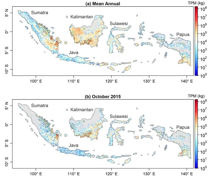
Get a related visualizationJPEG
Spatial patterns of the (a) mean annual total particulate matter (TPM) from...
-
Landing PageLanding Page
Dates
| Metadata Created Date | February 23, 2025 |
|---|---|
| Metadata Updated Date | February 23, 2025 |
Metadata Source
- Data.json Data.json Metadata
Harvested from nasa test json
Additional Metadata
| Resource Type | Dataset |
|---|---|
| Metadata Created Date | February 23, 2025 |
| Metadata Updated Date | February 23, 2025 |
| Publisher | ORNL_DAAC |
| Maintainer | |
| Identifier | C2600303267-ORNL_CLOUD |
| Data First Published | 2023-03-15 |
| Language | en-US |
| Data Last Modified | 2025-02-18 |
| Category | CMS, geospatial |
| Public Access Level | public |
| Bureau Code | 026:00 |
| Metadata Context | https://project-open-data.cio.gov/v1.1/schema/catalog.jsonld |
| Schema Version | https://project-open-data.cio.gov/v1.1/schema |
| Catalog Describedby | https://project-open-data.cio.gov/v1.1/schema/catalog.json |
| Harvest Object Id | 083a7d7c-39c0-4d51-980b-1651f731fc2a |
| Harvest Source Id | a73e0c30-4684-40ef-908e-d22e9e9e5f86 |
| Harvest Source Title | nasa test json |
| Homepage URL | https://doi.org/10.3334/ORNLDAAC/2118 |
| Metadata Type | geospatial |
| Old Spatial | 89.0 -11.0 153.0 10.1 |
| Program Code | 026:001 |
| Source Datajson Identifier | True |
| Source Hash | c016bcc397ba31a09cb49df9a4699bcd150a4e4f2fd9ead9585434c0bfab6e81 |
| Source Schema Version | 1.1 |
| Spatial | |
| Temporal | 2015-07-04T00:00:00Z/2020-12-31T23:59:59Z |
Didn't find what you're looking for? Suggest a dataset here.