

Delta-X: Calibrated ANUGA Hydrodynamic Outputs for the Atchafalaya Basin, MRD, LA
Access & Use Information
Public: This dataset is intended for public access and use.
Non-Federal: This dataset is covered by different Terms of Use than Data.gov.
License: No license information was provided.
Downloads & Resources
-
Google Scholar search resultsHTML
Search results for publications that cite this dataset by its DOI.
-
Download this datasetHTML
This link allows direct data access via Earthdata login
-
View documentation related to this datasetHTML
ORNL DAAC Data Set Documentation
-
This dataset's landing pageHTML
Data set Landing Page DOI URL
-
Use OPeNDAP to access the dataset's dataHTML
USE SERVICE API
-
View documentation related to this datasetPDF
Delta-X: Calibrated ANUGA Hydrodynamic Outputs for the Atchafalaya Basin,...
-
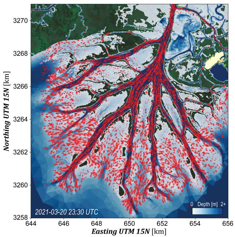
Get a related visualizationJPEG
ANUGA flow directions and depth at one timestep during the 2021 Spring campaign.
-
The dataset's project home pageHTML
Delta-X Project Site
-
Landing PageLanding Page
Dates
| Metadata Created Date | February 22, 2025 |
|---|---|
| Metadata Updated Date | February 22, 2025 |
Metadata Source
- Data.json Data.json Metadata
Harvested from nasa test json
Additional Metadata
| Resource Type | Dataset |
|---|---|
| Metadata Created Date | February 22, 2025 |
| Metadata Updated Date | February 22, 2025 |
| Publisher | ORNL_DAAC |
| Maintainer | |
| Identifier | C3091330782-ORNL_CLOUD |
| Data First Published | 2024-06-12 |
| Language | en-US |
| Data Last Modified | 2025-02-19 |
| Category | Delta-X, geospatial |
| Public Access Level | public |
| Bureau Code | 026:00 |
| Metadata Context | https://project-open-data.cio.gov/v1.1/schema/catalog.jsonld |
| Schema Version | https://project-open-data.cio.gov/v1.1/schema |
| Catalog Describedby | https://project-open-data.cio.gov/v1.1/schema/catalog.json |
| Harvest Object Id | d3f049b9-7569-4109-86b5-b94066f87e32 |
| Harvest Source Id | a73e0c30-4684-40ef-908e-d22e9e9e5f86 |
| Harvest Source Title | nasa test json |
| Homepage URL | https://doi.org/10.3334/ORNLDAAC/2306 |
| Metadata Type | geospatial |
| Old Spatial | -88.65 29.14 -88.3 29.54 |
| Program Code | 026:001 |
| Source Datajson Identifier | True |
| Source Hash | eaf1f0864fd60184b57e4bd4a0773752f8c44fc5520407beef04785a3b3442f9 |
| Source Schema Version | 1.1 |
| Spatial | |
| Temporal | 2016-10-15T00:00:00Z/2021-08-27T11:30:00Z |
Didn't find what you're looking for? Suggest a dataset here.