

CMS: LiDAR Data for Forested Sites on Borneo Island, Kalimantan, Indonesia, 2014
Access & Use Information
Public: This dataset is intended for public access and use.
Non-Federal: This dataset is covered by different Terms of Use than Data.gov.
License: No license information was provided.
Downloads & Resources
-
Google Scholar search resultsHTML
Search results for publications that cite this dataset by its DOI.
-
Download this datasetHTML
This link allows direct data access via Earthdata login
-
View documentation related to this datasetHTML
ORNL DAAC Data Set Documentation
-
This dataset's landing pageHTML
Data set Landing Page DOI URL
-
View documentation related to this datasetPDF
CMS_LiDAR_Indonesia.pdf
-
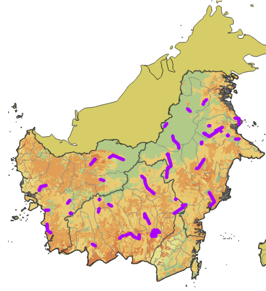
View documentation related to this datasetPNG
CMS_LiDAR_Indonesia_Fig1.png
-
View documentation related to this datasetPDF
Hagen_2015_AGU_poster.pdf
-
View documentation related to this datasetKML
indonesia_lidar_footprints.kmz
-
Get a related visualizationPNG
Browse Image
-
Landing PageLanding Page
Dates
| Metadata Created Date | February 22, 2025 |
|---|---|
| Metadata Updated Date | February 22, 2025 |
Metadata Source
- Data.json Data.json Metadata
Harvested from nasa test json
Additional Metadata
| Resource Type | Dataset |
|---|---|
| Metadata Created Date | February 22, 2025 |
| Metadata Updated Date | February 22, 2025 |
| Publisher | ORNL_DAAC |
| Maintainer | |
| Identifier | C2396938169-ORNL_CLOUD |
| Data First Published | 2024-05-01 |
| Language | en-US |
| Data Last Modified | 2025-02-19 |
| Category | CMS, geospatial |
| Public Access Level | public |
| Bureau Code | 026:00 |
| Metadata Context | https://project-open-data.cio.gov/v1.1/schema/catalog.jsonld |
| Schema Version | https://project-open-data.cio.gov/v1.1/schema |
| Catalog Describedby | https://project-open-data.cio.gov/v1.1/schema/catalog.json |
| Harvest Object Id | d60c44b1-6bf7-4841-be1a-498e4863e05e |
| Harvest Source Id | a73e0c30-4684-40ef-908e-d22e9e9e5f86 |
| Harvest Source Title | nasa test json |
| Homepage URL | https://doi.org/10.3334/ORNLDAAC/1518 |
| Metadata Type | geospatial |
| Old Spatial | 109.82 -2.76 118.0 3.21 |
| Program Code | 026:001 |
| Source Datajson Identifier | True |
| Source Hash | 534dfd4cca6ca7dc5bc52ac76377728c826c4ec5740146b5ee1e7145c8bea050 |
| Source Schema Version | 1.1 |
| Spatial | |
| Temporal | 2014-10-18T00:00:00Z/2014-11-30T23:59:59Z |
Didn't find what you're looking for? Suggest a dataset here.