

CAMEX-3 SCANNING RAMAN LIDAR V1
Access & Use Information
Downloads & Resources
-
Google Scholar search resultsHTML
Search results for publications that cite this dataset by its DOI.
-
Download this datasetHTML
Files may be downloaded directly to your workstation from this link
-
Get a related visualizationGIF
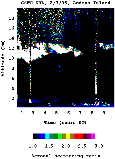
Sample browse image
-
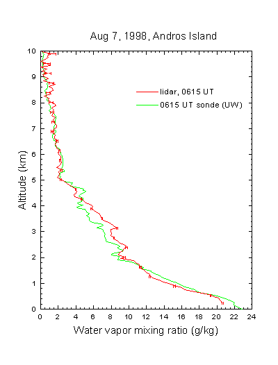
Get a related visualizationGIF
Sample browse image
-
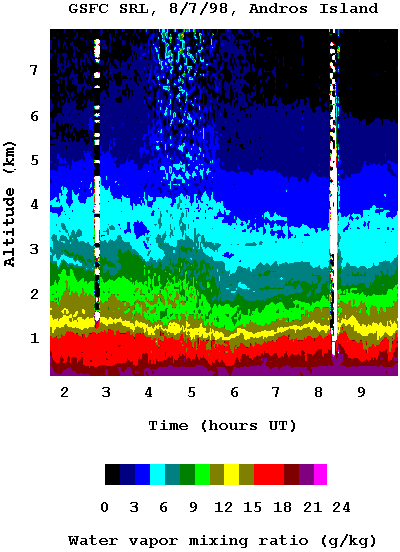
Get a related visualizationGIF
Sample browse image
-
View documentation related to this datasetHTML
The guide document contains detailed information about the dataset
-
View the primary investigator's documentation...HTML
Dataset README Document
-
View the primary investigator's documentation...HTML
Version 1.1 - calibrated data release for the NASA/GSFC Scanning Raman Lidar
-
The dataset's project home pageHTML
The home page for the project or program which sponsored the dataset
-
Get a related visualizationHTML
N/A
-
View documentation related to this datasetHTML
Instructions for citing GHRC data
-
Landing PageLanding Page
Dates
| Metadata Created Date | February 21, 2025 |
|---|---|
| Metadata Updated Date | February 21, 2025 |
Metadata Source
- Data.json Data.json Metadata
Harvested from nasa test json
Additional Metadata
| Resource Type | Dataset |
|---|---|
| Metadata Created Date | February 21, 2025 |
| Metadata Updated Date | February 21, 2025 |
| Publisher | NASA/MSFC/GHRC |
| Maintainer | |
| Identifier | C1979103958-GHRC_DAAC |
| Data First Published | 2000-03-31 |
| Language | en-US |
| Data Last Modified | 2025-02-19 |
| Category | CAMEX-3, geospatial |
| Public Access Level | public |
| Bureau Code | 026:00 |
| Metadata Context | https://project-open-data.cio.gov/v1.1/schema/catalog.jsonld |
| Schema Version | https://project-open-data.cio.gov/v1.1/schema |
| Catalog Describedby | https://project-open-data.cio.gov/v1.1/schema/catalog.json |
| Harvest Object Id | 80a78218-aae6-4987-a934-c69b2fee8681 |
| Harvest Source Id | a73e0c30-4684-40ef-908e-d22e9e9e5f86 |
| Harvest Source Title | nasa test json |
| Homepage URL | https://doi.org/10.5067/CAMEX-3/LIDAR/DATA102 |
| Metadata Type | geospatial |
| Old Spatial | -77.9 24.7 -77.8 24.8 |
| Program Code | 026:001 |
| Source Datajson Identifier | True |
| Source Hash | 5e64efcbbc7324c130e7757cf9d55e609af39d6a9e2e252653989ee39c276fd9 |
| Source Schema Version | 1.1 |
| Spatial | |
| Temporal | 1998-08-06T00:00:00Z/1998-09-20T23:59:59Z |
Didn't find what you're looking for? Suggest a dataset here.