

ATom: Global Modeled and CAFS Measured Cloudy and Clear Sky Photolysis Rates, 2016
Access & Use Information
Downloads & Resources
-
Google Scholar search resultsHTML
Search results for publications that cite this dataset by its DOI.
-
Download this datasetHTML
This link allows direct data access via Earthdata login
-
View documentation related to this datasetHTML
ORNL DAAC Data Set Documentation
-
This dataset's landing pageHTML
Data set Landing Page DOI URL
-
Use OPeNDAP to access the dataset's dataHTML
USE SERVICE API
-
View documentation related to this datasetPDF
Cloud impacts on photochemistry: a new climatology of photolysis rates from...
-
View documentation related to this datasetZIP
Atom: Global Modeled and CAFS Measured Cloudy and Clear Sky Photolysis Rates,...
-
View documentation related to this datasetHTML
Atom: Global Modeled and CAFS Measured Cloudy and Clear Sky Photolysis Rates,...
-
View documentation related to this datasetHTML
Atom: Global Modeled and CAFS Measured Cloudy and Clear Sky Photolysis Rates,...
-
View documentation related to this datasetHTML
Atom: Global Modeled and CAFS Measured Cloudy and Clear Sky Photolysis Rates,...
-
View documentation related to this datasetHTML
Atom: Global Modeled and CAFS Measured Cloudy and Clear Sky Photolysis Rates,...
-
View documentation related to this datasetHTML
Atom: Global Modeled and CAFS Measured Cloudy and Clear Sky Photolysis Rates,...
-
View documentation related to this datasetHTML
Atom: Global Modeled and CAFS Measured Cloudy and Clear Sky Photolysis Rates,...
-
View documentation related to this datasetHTML
Atom: Global Modeled and CAFS Measured Cloudy and Clear Sky Photolysis Rates,...
-
View documentation related to this datasetHTML
Atom: Global Modeled and CAFS Measured Cloudy and Clear Sky Photolysis Rates,...
-
View documentation related to this datasetHTML
Atom: Global Modeled and CAFS Measured Cloudy and Clear Sky Photolysis Rates,...
-
View documentation related to this datasetHTML
Atom: Global Modeled and CAFS Measured Cloudy and Clear Sky Photolysis Rates,...
-
View documentation related to this datasetHTML
Atom: Global Modeled and CAFS Measured Cloudy and Clear Sky Photolysis Rates,...
-
View documentation related to this datasetHTML
Atom: Global Modeled and CAFS Measured Cloudy and Clear Sky Photolysis Rates,...
-
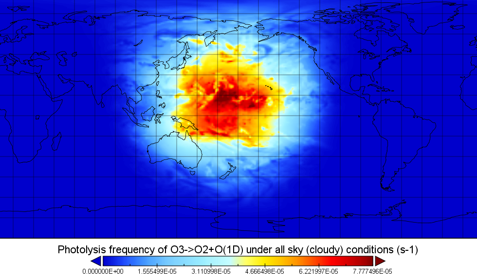
Get a related visualizationPNG
Figure 1: An image of photolysis frequency (J-value) for J-O1D under cloudy...
-
The dataset's project home pageHTML
ATom campaign page
-
Landing PageLanding Page
Dates
| Metadata Created Date | February 21, 2025 |
|---|---|
| Metadata Updated Date | February 21, 2025 |
Metadata Source
- Data.json Data.json Metadata
Harvested from nasa test json
Additional Metadata
| Resource Type | Dataset |
|---|---|
| Metadata Created Date | February 21, 2025 |
| Metadata Updated Date | February 21, 2025 |
| Publisher | ORNL_DAAC |
| Maintainer | |
| Identifier | C2704959373-ORNL_CLOUD |
| Data First Published | 2019-05-30 |
| Language | en-US |
| Data Last Modified | 2025-02-19 |
| Category | ATom, geospatial |
| Public Access Level | public |
| Bureau Code | 026:00 |
| Metadata Context | https://project-open-data.cio.gov/v1.1/schema/catalog.jsonld |
| Schema Version | https://project-open-data.cio.gov/v1.1/schema |
| Catalog Describedby | https://project-open-data.cio.gov/v1.1/schema/catalog.json |
| Harvest Object Id | 204cab33-1fc7-4827-92d5-350b91f94fc6 |
| Harvest Source Id | a73e0c30-4684-40ef-908e-d22e9e9e5f86 |
| Harvest Source Title | nasa test json |
| Homepage URL | https://doi.org/10.3334/ORNLDAAC/1651 |
| Metadata Type | geospatial |
| Old Spatial | -180.0 -90.0 180.0 90.0 |
| Program Code | 026:001 |
| Source Datajson Identifier | True |
| Source Hash | f363afdb630d22df7dbbfbf6b0e3cfed1a5645df037b5404ff4949f3821b9f45 |
| Source Schema Version | 1.1 |
| Spatial | |
| Temporal | 2005-08-01T00:00:00Z/2017-08-31T23:59:59Z |
Didn't find what you're looking for? Suggest a dataset here.