

ASCENDS: Airborne CO2 LAS Retrieval, Indianapolis, IN, USA, 2014
Access & Use Information
Public: This dataset is intended for public access and use.
Non-Federal: This dataset is covered by different Terms of Use than Data.gov.
License: No license information was provided.
Downloads & Resources
-
Google Scholar search resultsHTML
Search results for publications that cite this dataset by its DOI.
-
Download this datasetHTML
This link allows direct data access via Earthdata login
-
View documentation related to this datasetHTML
ORNL DAAC Data Set Documentation
-
This dataset's landing pageHTML
Data set Landing Page DOI URL
-
Use OPeNDAP to access the dataset's dataHTML
USE SERVICE API
-
View documentation related to this datasetPDF
ASCENDS: Airborne CO2 LAS Retrieval, Indianapolis, IN, USA, 2014:...
-
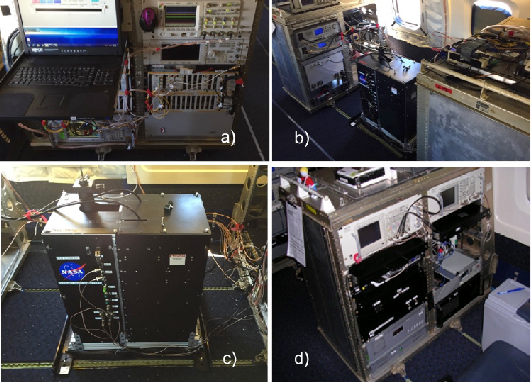
Get a related visualizationPNG
CO2 Sounder instrument photographs. a) The aircraft rack with the new seed...
-
Landing PageLanding Page
Dates
| Metadata Created Date | February 22, 2025 |
|---|---|
| Metadata Updated Date | February 22, 2025 |
Metadata Source
- Data.json Data.json Metadata
Harvested from nasa test json
Additional Metadata
| Resource Type | Dataset |
|---|---|
| Metadata Created Date | February 22, 2025 |
| Metadata Updated Date | February 22, 2025 |
| Publisher | ORNL_DAAC |
| Maintainer | |
| Identifier | C2734422038-ORNL_CLOUD |
| Data First Published | 2023-03-15 |
| Language | en-US |
| Data Last Modified | 2025-02-19 |
| Category | ASCENDS Airborne, geospatial |
| Public Access Level | public |
| Bureau Code | 026:00 |
| Metadata Context | https://project-open-data.cio.gov/v1.1/schema/catalog.jsonld |
| Schema Version | https://project-open-data.cio.gov/v1.1/schema |
| Catalog Describedby | https://project-open-data.cio.gov/v1.1/schema/catalog.json |
| Harvest Object Id | cdcd289f-2af3-4c6a-abcf-7df72b645de6 |
| Harvest Source Id | a73e0c30-4684-40ef-908e-d22e9e9e5f86 |
| Harvest Source Title | nasa test json |
| Homepage URL | https://doi.org/10.3334/ORNLDAAC/2116 |
| Metadata Type | geospatial |
| Old Spatial | -86.52 39.47 -85.76 40.15 |
| Program Code | 026:001 |
| Source Datajson Identifier | True |
| Source Hash | 2d93f03b9bcc07cf2a9b9ca15207b91a7b3d913f4b5ad44cc17a0eb346dfc209 |
| Source Schema Version | 1.1 |
| Spatial | |
| Temporal | 2014-09-03T12:43:17Z/2014-09-03T13:04:53Z |
Didn't find what you're looking for? Suggest a dataset here.