

Aqua/AIRS L3 Daily Support Daily Product (AIRS+AMSU+HSB) 1 degree x 1 degree V7.0 at GES DISC
Access & Use Information
Downloads & Resources
-
Google Scholar search resultsHTML
Search results for publications that cite this dataset by its DOI.
-
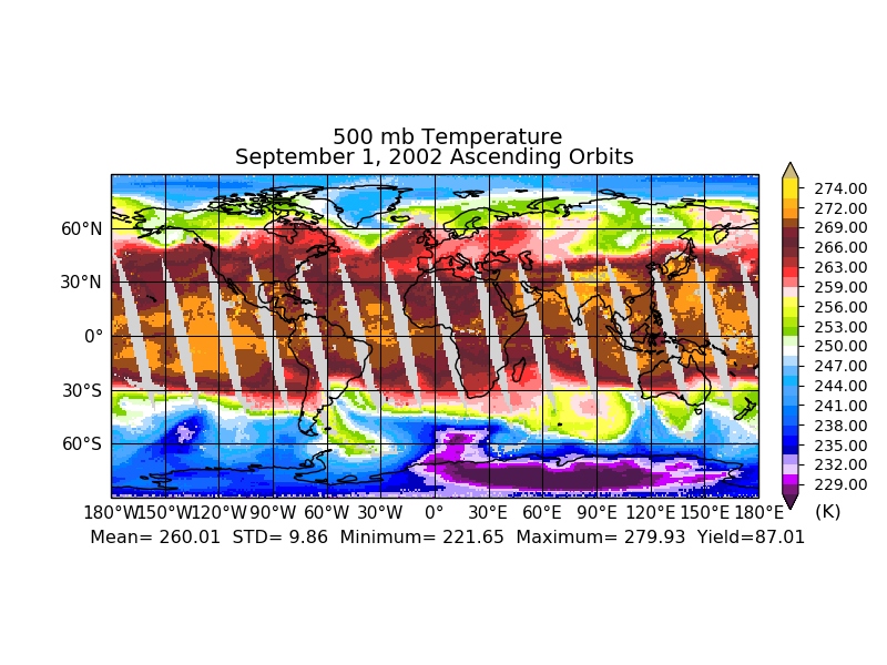
Get a related visualizationPNG
Sample data of the "AIRS/Aqua Level 3 daily standard physical retrieval...
-
This dataset's landing pageHTML
Access the dataset landing page from the GES DISC website.
-
Download this dataset through a directory mapHTML
Access the data via HTTP.
-
Use OPeNDAP to access the dataset's dataHTML
Access the data via the OPeNDAP protocol.
-
Download this dataset through Earthdata SearchHTML
Use the Earthdata Search to find and retrieve data sets across multiple data...
-
The dataset's project home pageHTML
AIRS home page at NASA/JPL. General information on the AIRS instrument,...
-
View information related to this datasetHTML
AIRS Documentation Page
-
View this dataset's read me documentPDF
Overview of the AIRS Mission: Instruments, Processing Algorithms, Products,...
-
View this dataset's user's guidePDF
AIRS Version 7 Level 3 Product User Guide
-
Landing PageLanding Page
Dates
| Metadata Created Date | February 22, 2025 |
|---|---|
| Metadata Updated Date | February 22, 2025 |
Metadata Source
- Data.json Data.json Metadata
Harvested from nasa test json
Additional Metadata
| Resource Type | Dataset |
|---|---|
| Metadata Created Date | February 22, 2025 |
| Metadata Updated Date | February 22, 2025 |
| Publisher | NASA/GSFC/SED/ESD/GCDC/GESDISC |
| Maintainer | |
| Identifier | C1701805696-GES_DISC |
| Data First Published | 2002-08-31 |
| Language | en-US |
| Data Last Modified | 2025-02-19 |
| Category | Aqua, geospatial |
| Public Access Level | public |
| Bureau Code | 026:00 |
| Metadata Context | https://project-open-data.cio.gov/v1.1/schema/catalog.jsonld |
| Schema Version | https://project-open-data.cio.gov/v1.1/schema |
| Catalog Describedby | https://project-open-data.cio.gov/v1.1/schema/catalog.json |
| Harvest Object Id | a622c193-a5ec-4f8f-b783-9a2367851f9d |
| Harvest Source Id | a73e0c30-4684-40ef-908e-d22e9e9e5f86 |
| Harvest Source Title | nasa test json |
| Homepage URL | https://doi.org/10.5067/B0MMJS2ZBNR9 |
| Metadata Type | geospatial |
| Old Spatial | -180.0 -90.0 180.0 90.0 |
| Program Code | 026:001 |
| Source Datajson Identifier | True |
| Source Hash | 4b2b80169ec7a2e62febbfcb78a594edcf3a7edf7310f565f525e61fa2f1bf39 |
| Source Schema Version | 1.1 |
| Spatial | |
| Temporal | 2002-08-31T00:00:00Z/2022-01-17T00:00:00Z |
Didn't find what you're looking for? Suggest a dataset here.