

ABoVE: Dall Sheep Lamb Recruitment and Climate Data, Alaska and NW Canada, 2000-2015
Access & Use Information
Public: This dataset is intended for public access and use.
Non-Federal: This dataset is covered by different Terms of Use than Data.gov.
License: No license information was provided.
Downloads & Resources
-
Google Scholar search resultsHTML
Search results for publications that cite this dataset by its DOI.
-
Download this datasetHTML
This link allows direct data access via Earthdata login
-
View documentation related to this datasetHTML
ORNL DAAC Data Set Documentation
-
This dataset's landing pageHTML
Data set Landing Page DOI URL
-
View documentation related to this datasetPDF
ABoVE: Range-wide Dall Sheep Lamb-to-Ewe Ratios, Environment and Climate,...
-
View documentation related to this datasetKML
ABoVE: Range-wide Dall Sheep Lamb-to-Ewe Ratios, Environment and Climate,...
-
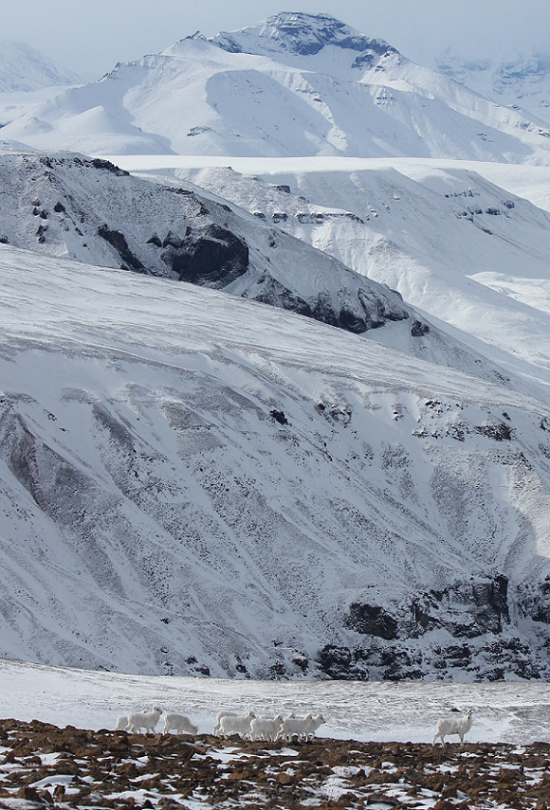
Get a related visualizationJPEG
A herd of Dall sheep ewes and lambs are dwarfed by the mountainous landscape...
-
The dataset's project home pageHTML
ABoVE project site
-
Landing PageLanding Page
Dates
| Metadata Created Date | February 22, 2025 |
|---|---|
| Metadata Updated Date | February 22, 2025 |
Metadata Source
- Data.json Data.json Metadata
Harvested from nasa test json
Additional Metadata
| Resource Type | Dataset |
|---|---|
| Metadata Created Date | February 22, 2025 |
| Metadata Updated Date | February 22, 2025 |
| Publisher | ORNL_DAAC |
| Maintainer | |
| Identifier | C2162145802-ORNL_CLOUD |
| Data First Published | 2022-11-28 |
| Language | en-US |
| Data Last Modified | 2025-02-19 |
| Category | ABoVE, geospatial |
| Public Access Level | public |
| Bureau Code | 026:00 |
| Metadata Context | https://project-open-data.cio.gov/v1.1/schema/catalog.jsonld |
| Schema Version | https://project-open-data.cio.gov/v1.1/schema |
| Catalog Describedby | https://project-open-data.cio.gov/v1.1/schema/catalog.json |
| Harvest Object Id | f38847b0-9b2f-4ffd-b2ac-f5d2f0a650d4 |
| Harvest Source Id | a73e0c30-4684-40ef-908e-d22e9e9e5f86 |
| Harvest Source Title | nasa test json |
| Homepage URL | https://doi.org/10.3334/ORNLDAAC/1640 |
| Metadata Type | geospatial |
| Old Spatial | -163.28 59.6 -123.55 69.71 |
| Program Code | 026:001 |
| Source Datajson Identifier | True |
| Source Hash | 442c42bae12131d46ef4b37b3c7e41eefb659b6a7f3845704840323234459d5b |
| Source Schema Version | 1.1 |
| Spatial | |
| Temporal | 2000-01-01T00:00:00Z/2015-12-31T23:59:59Z |
Didn't find what you're looking for? Suggest a dataset here.