

73 datasets found
-
Global MODIS and FLUXNET-derived Daily Gross Primary Production, V2 NGDA
NASA Test —
This dataset provides global gridded daily estimates of gross primary production (GPP) and uncertainties at 0.05-degree resolution for the period 2000-03-01 to the... -
ABoVE: Light-Curve Modelling of Gridded GPP Using MODIS MAIAC and Flux Tower Data NGDA
NASA Test —
This dataset contains gridded estimations of daily ecosystem Gross Primary Production (GPP) in grams of carbon per day at a 1 km2 spatial resolution over Alaska and... -
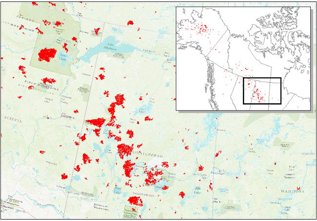
ABoVE: Wildfire Date of Burning within Fire Scars across Alaska and Canada, 2001-2019 NGDA
NASA Test —
This dataset provides estimates of wildfire progression represented by date of burning (DoB) within fire scars across Alaska and Canada for the period 2001-2019. Burn... -
Siberian Boreal Forest Aboveground Biomass and Fire Scar Maps, Russia, 1969-2007 NGDA
NASA Test —
This data set provides 30-meter resolution mapped estimates of Cajander larch (Larix cajanderi) aboveground biomass (AGB), circa 2007, and a map of burn perimeters for... -
Net Radiation and Albedo from MODIS for Xingu River Basin, Brazil, 2000-2012 NGDA
NASA Test —
This dataset provides daily average land surface net radiation (Rnet) as an 8-day time series at approximately 0.5 km resolution for the upper Xingu River Basin in... -
LBA-ECO LC-39 MODIS Active Fire and Frequency Data for South America: 2000-2007 NGDA
NASA Test —
This data set provides active fire locations and estimates of annual fire frequencies for South America from 2000-2007. Data from the Moderate Resolution Imaging... -
Annual wildland fire emissions (WFEIS v0.5) for Conterminous US and Alaska, 2001-2013 NGDA
NASA Test —
This data set contains annual modeled estimates of wildland fire emissions at 0.01 degree (~1-km) spatial resolution from the Wildland Fire Emissions Information... -
Synthesis of Winter In Situ Soil CO2 Flux in pan-Arctic and Boreal Regions, 1989-2017 NGDA
NASA Test —
This dataset provides a synthesis of winter ( September-April) in situ soil CO2 flux measurement data from locations across pan-Arctic and Boreal permafrost regions.... -
ABoVE: High Resolution Cloud-Free Snow Cover Extent and Snow Depth, Alaska, 2001-2017 NGDA
NASA Test —
This dataset provides estimates of maximum snow cover extent (SCE) and snow depth for each 8-day composite period from 2001 to 2017 at 1 km resolution across Alaska.... -
Global Fire Atlas with Characteristics of Individual Fires, 2003-2016 NGDA
NASA Test —
The Global Fire Atlas is a global dataset that tracks the day-to-day dynamics of individual fires to determine the timing and location of ignitions, fire size,... -
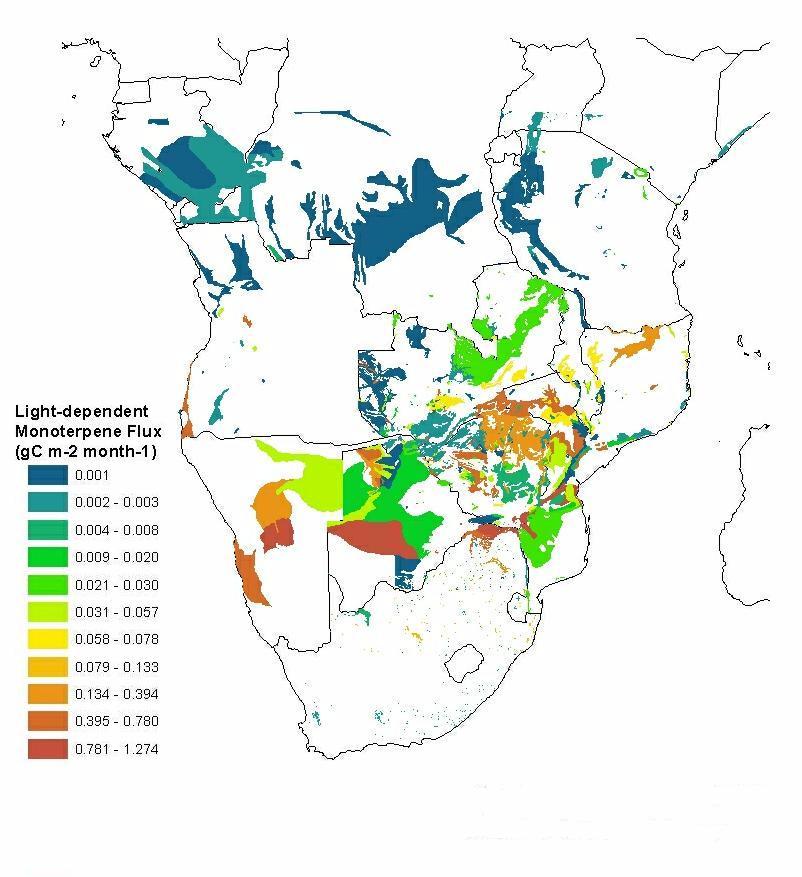
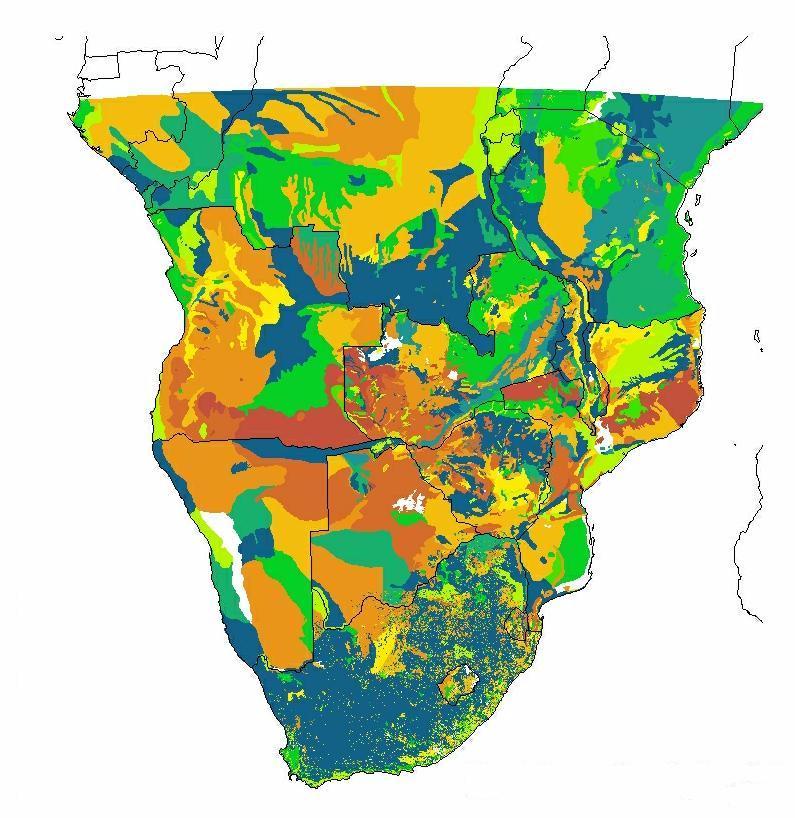
SAFARI 2000 Estimated BVOC Emissions for Southern African Land Cover Types NGDA
NASA Test —
Improved vegetation distribution and emission data for Africa south of the equator were developed for the Southern African Regional Science Initiative (SAFARI 2000)... -
Russian Boreal Forest Disturbance Maps Derived from Landsat Imagery, 1984-2000 NGDA
NASA Test —
This data set provides Boreal forest disturbance maps at 30-m resolution for 55 selected sites across Northern Eurasia within the Russian Federation. Disturbance... -
ABoVE: Rain-on-Snow Frequency and Distribution during Cold Seasons, Alaska, 2003-2016 NGDA
NASA Test —
This dataset provides maps of rain-on-snow (ROS) events across Alaska for the individual months of November to March 2002-2011 and November to March 2012-2016, and... -
ISLSCP II Snow-Free, Spatially Complete, 16 Day Albedo, 2002 NGDA
NASA Test —
This data set, ISLSCP II Snow-Free, Spatially Complete, 16 Day Albedo, 2002, contains 9 files for snow-free, spatially complete 16-day global black-sky albedos at... -
SAFARI 2000 MODIS MOD04_L2 Aerosol Data, GRANT Format, for Southern Africa NGDA
NASA Test —
The subset of the MODIS MOD04_L2 aerosol product provided in this data set represents the swaths that coincide with known times of the South African Weather...
73 datasets found