

1,264 datasets found
-
IPAB Antarctic Drifting Buoy Data, Version 1
NASA Test —
Through participating research organizations in various countries, the World Climate Research Programme's (WCRP) International Programme for Antarctic Buoys (IPAB)... -
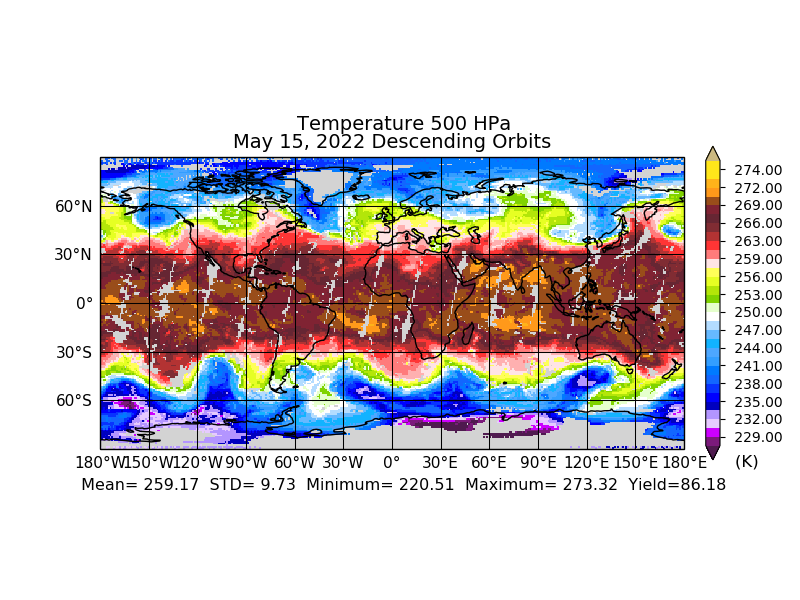
Sounder SIPS: JPSS-1 ATMS Level 3 RAMSES2 Standard Gridded Daily V3 at GES DISC
NASA Test —
This level 3 daily product is generated from the RAMSES (Retrieval Algorithm for Microwave Sounders in Earth Science) II algorithm.The RAMSES II algorithm is a... -
RSS SMAP Level 3 Sea Surface Salinity Standard Mapped Image Monthly V5.3 Validated Dataset
NASA Test —
The RSS SMAP Level 3 Sea Surface Salinity Standard Mapped Image Monthly V5.3 Validated Dataset produced by the Remote Sensing Systems (RSS) and sponsored by the NASA... -
GHRSST Level 4 GAMSSA_28km Global Foundation Sea Surface Temperature Analysis v1.0 dataset (GDS2)
NASA Test —
A Group for High Resolution Sea Surface Temperature (GHRSST) Level 4 sea surface temperature analysis, produced daily on an operational basis at the Australian Bureau... -
ECCO Sea Surface Height - Monthly Mean llc90 Grid (Version 4 Release 4b)
NASA Test —
This dataset provides monthly-averaged dynamic sea surface height and model sea level anomaly on the native Lat-Lon-Cap 90 (LLC90) model grid from the ECCO Version 4... -
Aquarius Official Release Level 3 Rain-flagged Sea Surface Salinity Standard Mapped Image Seasonal Climatology Data V5.0
NASA Test —
Aquarius Level 3 sea surface salinity (SSS) rain-flagged standard mapped image data contains gridded 1 degree spatial resolution SSS averaged over daily, 7 day,... -
NASA Ocean Biogeochemical Model assimilating satellite chlorophyll data global monthly VR2017 (NOBM_MON) at GES DISC
NASA Test —
This is the assimilated monthly data from NASA Ocean Biogeochemical Model (NOBM). The NOBM is a comprehensive, interactive ocean biogeochemical model coupled with a... -
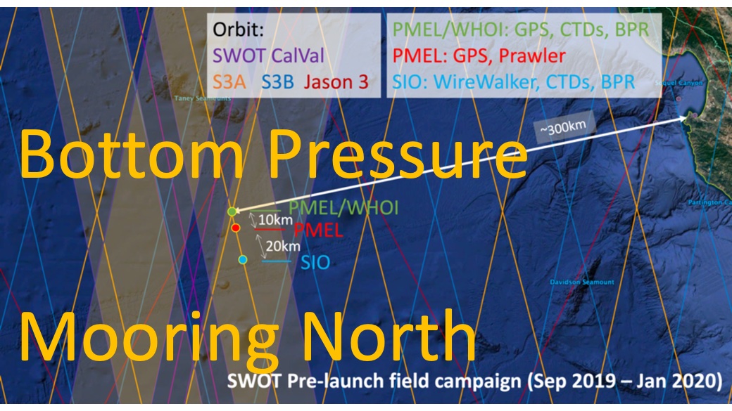
SWOT 2019-2020 Prelaunch Oceanography Field Campaign NOAA Bottom Pressure Recorders (BPR)
NASA Test —
This dataset provides the bottom pressure measurements collected during the 2019-2020 SWOT prelaunch field campaign conducted around the SWOT crossover location in the... -
SWOT Level 2 Nadir Altimeter Interim Geophysical Data Record with Waveforms - GDR Version 1.0
NASA Test —
Same as L2_NALT_GDR, using preliminary values for some auxiliary data. Uses Medium-accuracy (preliminary) Orbit Ephemeris (MOE). Available with latency of < 1.5... -
GHRSST Level 2P Global Subskin Sea Surface Temperature from TRMM Microwave Imager (TMI) onboard Tropical Rainfall Measurement Mission (TRMM) satellite
NASA Test —
GDS2 Version -The Tropical Rainfall Measuring Mission (TRMM) Microwave Imager (TMI) is a well calibrated passive microwave radiometer, similar to the Special Sensor... -
Glider measurements near Tampa, FL
NASA Test —
Measurements made near Tampa along the Florida Gulf Coast to calibrate and validate glider instrumentation between 2009 and 2011. -
Measurements along the Massachusetts and Maine coast
NASA Test —
Measurements taken along the Massachusetts and Maine coastal regions in 2007. -
SENTINEL-1A_DUAL_POL_METADATA_GRD_MEDIUM_RES
NASA Test —
Sentinel-1A Dual-pol ground projected medium resolution metadata -
Aquarius Official Release Level 3 Ancillary Reynolds Sea Surface Temperature Standard Mapped Image Monthly Data V5.0
NASA Test —
Aquarius Level 3 ancillary sea surface temperature (SST) standard mapped image data are the ancillary SST data used in the Aquarius calibration for salinity retrieval.... -
CYGNSS Level 2 Science Data Record Version 2.1
NASA Test —
This dataset contains the Version 2.1 CYGNSS Level 2 Science Data Record which provides the time-tagged and geolocated average wind speed (m/s) and mean square slope... -
Gulf of Mexico measurements in 1993
NASA Test —
Measurements from the Gulf of Mexico along the Florida and Louisiana coasts in 1993. -
Measurements onboard the Turkish research vessel Bilim
NASA Test —
Measurements from the Turkish Seas during 1999 and 2000 by the Turkish research vessel, the Bilim. -
NOAA/NMC/CAC Arctic and Antarctic Monthly Sea Ice Extent, 1973-1990, Version 1
NASA Test —
Sea ice extent from January 1973 through August 1990 was digitized from weekly operational sea ice charts produced by the Navy/NOAA Joint Ice Center. Charts were...
1,264 datasets found