

4,387 datasets found
-
MODIS/Terra+Aqua Direct Broadcast Burned Area Monthly L3 Global 500m SIN Grid V061 NGDA
NASA Test —
The Terra and Aqua combined MCD64A1 Version 6.1 Burned Area data product is a monthly, global gridded 500 meter (m) product containing per-pixel burned-area and... -
TES/Aura L2 Ozone Nadir V008
NASA Test —
TL2O3N_8 is the Tropospheric Emission Spectrometer (TES)/Aura Level 2 Ozone Nadir Version 8 data product. It consists of information for one molecular species for an... -
Distributed Anomaly Detection using 1-class SVM for Vertically Partitioned Data
NASA Test —
There has been a tremendous increase in the volume of sensor data collected over the last decade for different monitoring tasks. For example, petabytes of earth... -
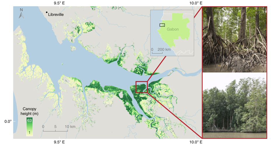
Global Mangrove Distribution, Aboveground Biomass, and Canopy Height
NASA Test —
This dataset characterizes the global distribution, biomass, and canopy height of mangrove-forested wetlands based on remotely sensed and in situ field measurement... -
Gazetteer of Planetary Nomenclature: Venus: 1:5 million-scale Magellan Imagery
NASA Test —
Magellan imagery of Venus approved by the International Astronomical Union (IAU). -
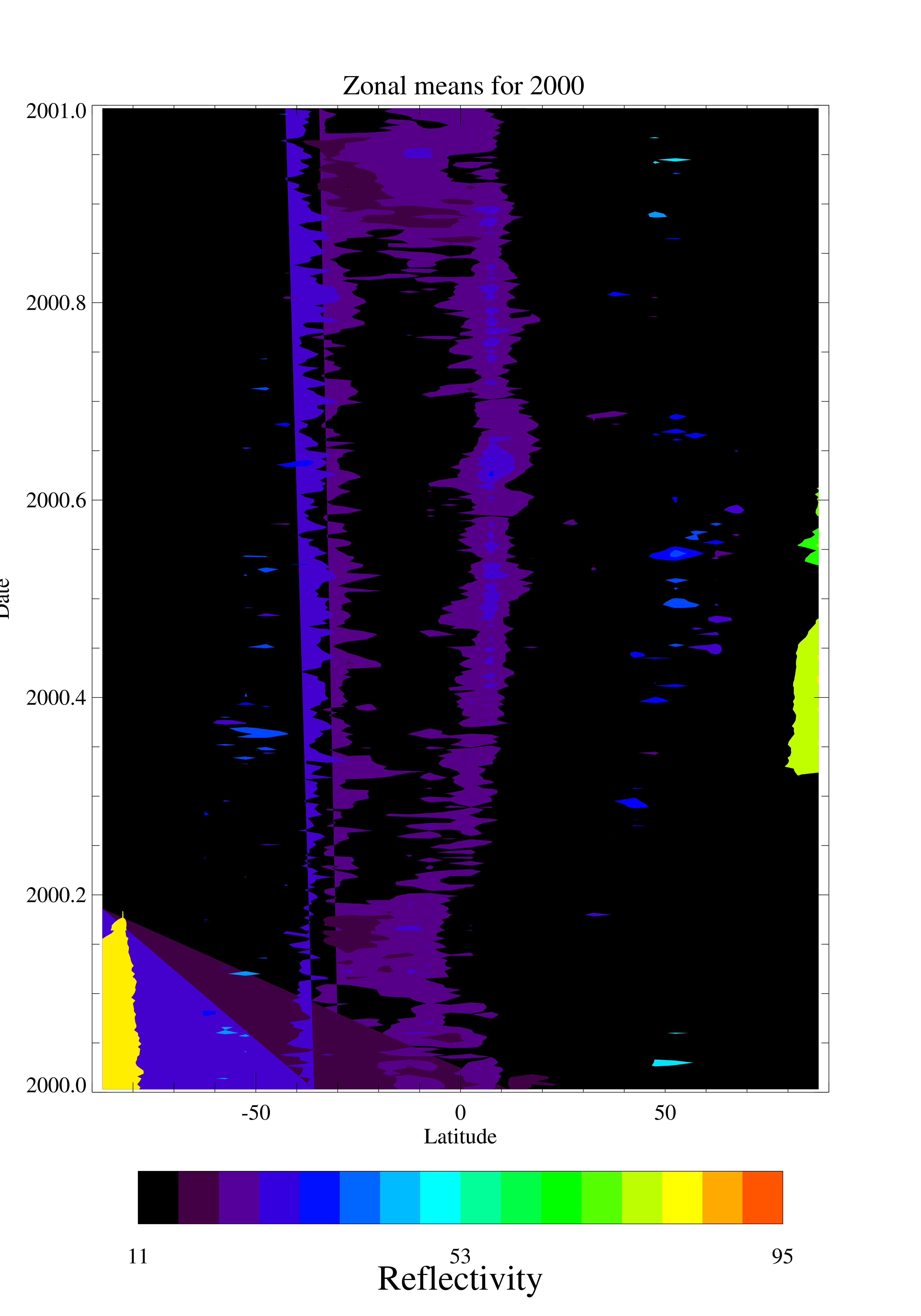
TOMS EP UV Reflectivity Daily and Monthly Zonal Means V008 (TOMSEPL3zref) at GES DISC
NASA Test —
This Earth Probe (EP) Total Ozone Mapping Spectrometer (TOMS) version 8 daily zonal means data product contains Lambertian effective surface reflectivity values... -
OMPS-NPP L2 NP Ozone (O3) Vertical Profile swath orbital
NASA Test —
The OMPS-NPP L2 NP Ozone (O3) Total Column swath orbital product provides ozone profile retrievals from the Ozone Mapping and Profiling Suite (OMPS) Nadir-Profiler... -
GHRSST Level 4 MW_IR_OI Global Foundation Sea Surface Temperature analysis version 5.0 from REMSS NGDA
NASA Test —
A Group for High Resolution Sea Surface Temperature (GHRSST) global Level 4 sea surface temperature analysis produced daily on a 0.09-degree grid at Remote Sensing... -
Digital Elevation Models for the Global Change Research Wetland, Maryland, USA, 2016
NASA Test —
This dataset contains four alternative digital elevation models (DEMs) at 1 m resolution and model performance statistical metrics for the Global Change Research... -
Gazetteer of Planetary Nomenclature: Saturnian System: Titan
NASA Test —
These images display several of Saturn's moons approved by the International Astronomical Union (IAU). -
TOVS GLA MONTHLY GRIDS from NOAA-11 V01 (TOVSAMNH) at GES DISC
NASA Test —
This dataset (TOVSAMNH) contains the TIROS Operational Vertical Sounder (TOVS) level 3 geophysical parameters derived using data from NOAA-11 and the physical... -
ACT-America: L1 Raw, Uncalibrated In-Situ CO2, CO, and CH4 Mole Fractions from Towers
NASA Test —
This dataset provides Level 1 (L1) in situ atmospheric carbon dioxide (CO2), carbon monoxide (CO), and methane (CH4) concentrations as measured on a network of... -
MODIS/Terra+Aqua Photosynthetically Active Radiation Daily/3-Hour L3 Global 0.05Deg CMG V062 NGDA
NASA Test —
The MCD18C2 Version 6.2 is a Moderate Resolution Imaging Spectroradiometer (MODIS) Terra and Aqua combined Photosynthetically Active Radiation (PAR) gridded Level 3... -
NLDAS Secondary Forcing Data L4 Monthly 0.125 x 0.125 degree V2.0 (NLDAS_FORB0125_M) at GES DISC
NASA Test —
This data set contains the monthly secondary forcing data "File B" for Phase 2 of the North American Land Data Assimilation System (NLDAS-2). The data are in 1/8th... -
Gazetteer of Planetary Nomenclature: Venus: 1:10 million-scale Altimetry Quadrangles: Niobe
NASA Test —
This set of maps diplays altimetric radar images of Venus approved by the International Astronomical Union (IAU). -
Gazetteer of Planetary Nomenclature: Neptunian System: Triton
NASA Test —
These images display several of Neptune's moons approved by the International Astronomical Union (IAU). -
NLDAS Noah Land Surface Model L4 Monthly 0.125 x 0.125 degree V2.0 (NLDAS_NOAH0125_M) at GES DISC
NASA Test —
This data set contains fifty-two fields simulated from the Noah land-surface model (LSM) for Phase 2 of the North American Land Data Assimilation System (NLDAS-2). The... -
GEWEX SRB Integrated Product (Rel-4) Shortwave Monthly Average by Local Fluxes
NASA Test —
GEWEXSRB_Rel4-IP_Shortwave_monthly_local is the Global Energy and Water Exchanges (GEWEX) Surface Radiation Budget (SRB) Integrated Product (Rel-4) Shortwave Monthly... -
RapidScat Level 2A Surface Flagged Sigma-0 and Attenuations in 25km Swath Grid Version 2.0
NASA Test —
This dataset contains the Version 2.0 ISS-RapidScat Level 2A 25km science data record, which provides surface-flagged sigma-0 in 25km Wind Vector Cells processed using... -
GPM IMERG Final Precipitation L3 1 month 0.1 degree x 0.1 degree V07 (GPM_3IMERGM) at GES DISC
NASA Test —
Version 07 is the current version of the data set. Older versions will no longer be available and have been superseded by Version 07. The Integrated Multi-satellitE...
4,387 datasets found