

1,163 datasets found
-
Global MODIS and FLUXNET-derived Daily Gross Primary Production, V2 NGDA
NASA Test —
This dataset provides global gridded daily estimates of gross primary production (GPP) and uncertainties at 0.05-degree resolution for the period 2000-03-01 to the... -
ATom: Ozone Profiles from Ozonesonde Instrument, Antarctica, Fiji, and Hawaii
NASA Test —
This dataset contains ozone measurements from the Ozonesonde instrument in Antarctica, Hawaii, and Fiji taken during the Atom-4 campaign. The Electrochemical... -
VEMAP 1: U.S. Soil
NASA Test —
An integrated input data set for ecosystem and vegetation modeling for the conterminous United States: Soil -
ABoVE: Light-Curve Modelling of Gridded GPP Using MODIS MAIAC and Flux Tower Data NGDA
NASA Test —
This dataset contains gridded estimations of daily ecosystem Gross Primary Production (GPP) in grams of carbon per day at a 1 km2 spatial resolution over Alaska and... -
Global-Gridded Daily Methane Emissions Climatology from Lake Systems, 2003-2015
NASA Test —
This dataset provides global gridded information on lake surface area and open water CH4 emissions at a resolution of 0.25-degree x 0.25-degree for an annual... -
SAFARI 2000 TOMS Tropospheric Ozone Data, Southern Africa Subset, Dry Season 2000
NASA Test —
Tropical Tropospheric Ozone (TTO) data from Earth Probe (EP) Total Ozone Mapping Spectrometer (TOMS) for the period of August 8-September 29, 2000 were processed and... -
NACP Greenhouse Gases Multi-Source Data Compilation, 2000-2009
NASA Test —
This data set is a collection of measurements of carbon dioxide (CO2) and non-CO2 greenhouse gases made across North America by nine independent atmospheric monitoring... -
BOREAS TE-20 Site Characteristics Data
NASA Test —
The BOREAS TE-20 team collected several data sets for use in developing and testing models of forest ecosystem dynamics. This data set contains measurements of site... -
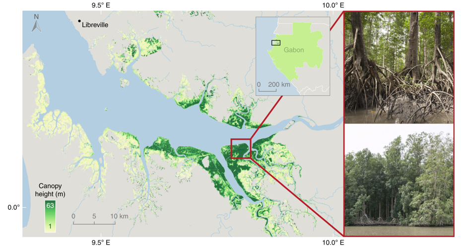
Global Mangrove Distribution, Aboveground Biomass, and Canopy Height
NASA Test —
This dataset characterizes the global distribution, biomass, and canopy height of mangrove-forested wetlands based on remotely sensed and in situ field measurement... -
Digital Elevation Models for the Global Change Research Wetland, Maryland, USA, 2016
NASA Test —
This dataset contains four alternative digital elevation models (DEMs) at 1 m resolution and model performance statistical metrics for the Global Change Research... -
ACT-America: L1 Raw, Uncalibrated In-Situ CO2, CO, and CH4 Mole Fractions from Towers
NASA Test —
This dataset provides Level 1 (L1) in situ atmospheric carbon dioxide (CO2), carbon monoxide (CO), and methane (CH4) concentrations as measured on a network of... -
Global Vegetation Greenness (NDVI) from AVHRR GIMMS-3G+, 1981-2022
NASA Test —
This dataset holds the Global Inventory Modeling and Mapping Studies-3rd Generation V1.2 (GIMMS-3G+) data for the Normalized Difference Vegetation Index (NDVI). NDVI... -
Delta-X: UAVSAR L2 Interferometric Products, MRD, Louisiana, 2021
NASA Test —
This dataset contains georeferenced UAVSAR Level 2 (L2) interferometric products for Delta-X flight lines acquired during the spring (2021-03-27 to 2021-04-18) and... -
Trends of Thermal, Wetness, and Vegetative Change in the Circumpolar Arctic
NASA Test —
This dataset provides estimates of trends in temperature, moisture, and vegetation changes over the circumpolar Arctic. Time series trends were measured by the Theil-...
1,163 datasets found