

7,630 datasets found
-
Address SMD and ANC Changes
State of Washington —
Addresses that have changed ANC and SMD as a result of new delineations in the Advisory Neighborhood Commission Boundaries Act of 2022, signed into law on June 16,... -
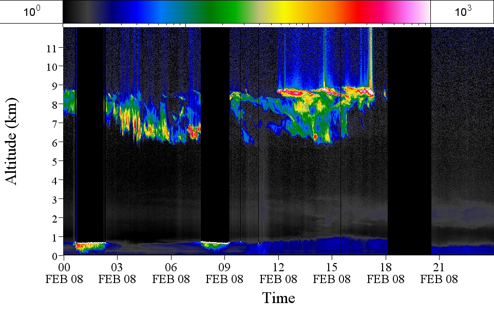
GPM GROUND VALIDATION AEROSOL AND WATER VAPOR LIDAR QUICKLOOKS GCPEX V1
NASA Test —
The GPM Ground Validation Aerosol and Water Vapor Lidar Quicklooks GCPEx dataset contains imagery generated from the GPM Cold-season Precipitation Experiment (GCPEx)... -
VIIRS/NPP BRDF/Albedo Quality Daily L3 Global 500m SIN Grid V001
NASA Test —
The NASA/NOAA Suomi National Polar-orbiting Partnership (Suomi NPP) Visible Infrared Imaging Radiometer Suite (VIIRS) Bidirectional Reflectance Distribution Function... -
FLDAS Noah Land Surface Model L4 Global Monthly 0.1 x 0.1 degree (GDAS and CHIRPS-PRELIM) V001 (FLDAS_NOAH01_CP_GL_M) at GES DISC
NASA Test —
This dataset contains a series of land surface parameters simulated from the Noah 3.6.1 model in the Famine Early Warning Systems Network (FEWS NET) Land Data... -
National Oceanographic Partnership Program ARGO profiling floats
NASA Test —
Measurements from the NOPP (National Oceanographic Partnership Program) as collected by ARGO profiling floats. -
Capital Bikeshare Locations
State of Washington —
Capital Bikeshare is metro DC's bikeshare service, with 5,000 bikes and 600+ stations across 7 jurisdictions: Washington, DC.; Arlington, VA; Alexandria, VA;... -
Gulf of Guinea climate and ocean circulation study (EGEES)
NASA Test —
Measurements made in the Gulf of Guinea off of west-central Africa in 2007 as part of the fifth cruise in the EGEE project (Gulf of Guinea climate and ocean... -
ABoVE: Light-Curve Modelling of Gridded GPP Using MODIS MAIAC and Flux Tower Data NGDA
NASA Test —
This dataset contains gridded estimations of daily ecosystem Gross Primary Production (GPP) in grams of carbon per day at a 1 km2 spatial resolution over Alaska and... -
Intermediate Care Facilities
State of Washington —
Intermediate Care Facility. This dataset contains points representing Intermediate Care Facility locations, created as part of the DC Geographic Information System (DC... -
Global-Gridded Daily Methane Emissions Climatology from Lake Systems, 2003-2015
NASA Test —
This dataset provides global gridded information on lake surface area and open water CH4 emissions at a resolution of 0.25-degree x 0.25-degree for an annual... -
GPM GROUND VALIDATION AUTONOMOUS PARSIVEL UNIT (APU) IPHEx V1
NASA Test —
The GPM Ground Validation NASA Autonomous Parsivel Unit (APU) IPHEx dataset was acquired by multiple parsivel instruments during the GPM Integrated Precipitation and... -
Gulf of Mexico and East Coast Carbon Cruise (GOMECC)
NASA Test —
The Gulf of Mexico and East Coast Carbon Cruise (GOMECC) -
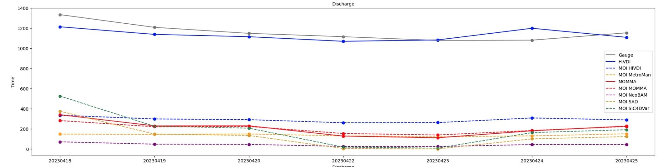
SWOT Sword of Science River Discharge Products Version 1
NASA Test —
The SWOT Sword of Science River Discharge Products dataset from the Surface Water and Ocean Topography (SWOT) mission and produced by the Discharge Algorithm Working... -
Measurements in Lake Okeechobee, Florida, 1997 - 1999
NASA Test —
Optical measurements made in Lake Okeechobee, Florida, between 1997 and 1999 -
First ISCCP Regional Experiment (FIRE) Atlantic Stratocumulus Transition Experiment (ASTEX) Rawinsonde Level 1 Data
NASA Test —
The First ISCCP Regional Experiments have been designed to improve data products and cloud/radiation parameterizations used in general circulation models (GCMs).... -
MERRA-2 instU_3d_asm_Np: 3d,diurnal,Instantaneous,Pressure-Level,Assimilation,Assimilated Meteorological Fields 0.625 x 0.5 degree V5.12.4 (M2IUNPASM) at GES DISC
NASA Test —
M2IUNPASM (or instU_3d_asm_Np) is an instantaneous 3-dimensional monthly diurnal means data collection in Modern-Era Retrospective analysis for Research and...
7,630 datasets found