

13,837 datasets found
-
ROSETTA-ORBITER STEINS RPCIES 2 AST1 V1.0
NASA Test —
This dataset contains EDITED RAW DATA of the RPCIES instrument taken during the asteroid Steins encounter (AST1). Included are the data taken between 11 Jul 2008 and... -
GPM Ground Validation Pluvio Precipitation Gauges OLYMPEX V1
NASA Test —
The GPM Ground Validation Pluvio Precipitation Gauges OLYMPEX dataset contains one-minute precipitation rate and precipitation accumulation measurements, as well as... -
VEMAP 1: U.S. Soil
NASA Test —
An integrated input data set for ecosystem and vegetation modeling for the conterminous United States: Soil -
Woman skeletal muscle transcriptome with bed rest and countermeasures.
NASA Test —
Microgravity has a dramatic impact on human physiology illustrated in particular with skeletal muscle impairment. A thorough understanding of the mechanisms leading to... -
Global Population Density Grid Time Series Estimates
NASA Test —
The Global Population Density Grid Time Series Estimates provide a back-cast time series of population density grids based on the year 2000 population grid from... -
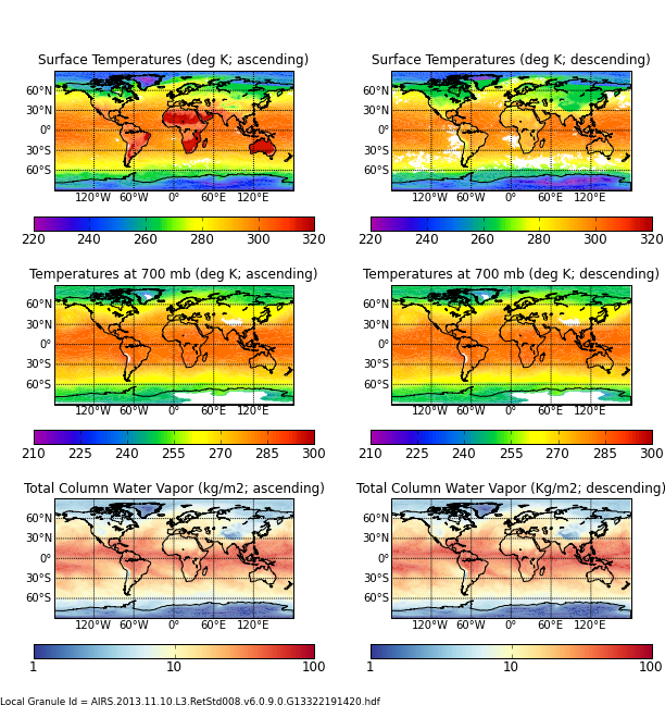
AIRS/Aqua L3 8-day Support Multiday Product (AIRS+AMSU) 1 degree x 1 degree V006 (AIRX3SP8) at GES DISC
NASA Test —
The Atmospheric Infrared Sounder (AIRS) is a grating spectrometer (R = 1200) aboard the second Earth Observing System (EOS) polar-orbiting platform, EOS Aqua. In... -
Nimbus-7 Coastal Zone Color Scanner (CZCS) Data Regional Data
NASA Test —
The Coastal Zone Color Scanner Experiment (CZCS) was the first instrument devoted to the measurement of ocean color and flown on a spacecraft. Although other... -
GPM Ground Validation Autonomous Parsivel Unit (APU) OLYMPEX V1
NASA Test —
The GPM Ground Validation Autonomous Parsivel Unit (APU) OLYMPEX dataset was collected during the OLYMPEX field campaign held at Washington's Olympic Peninsula during... -
Aviation Safety Reporting System: Parachutist / Aircraft Conflicts
NASA Test —
A sampling of reports involving parachuting activity and conflicts with aircraft. -
SAGE III/ISS L2 Monthly Lunar Event Species Profiles (NetCDF) V053
NASA Test —
g3blmnc_53 is the Stratospheric Aerosol and Gas Experiment III (SAGE III) on the International Space Station (ISS) (SAGE III/ISS) Level 2 Monthly Lunar Event Species... -
NASA 3D Models: Deep Space 1
NASA Test —
This .stl file was produced by scaling the original model and converting it directly to .stl format. -
SASS (Subsonics Assessment) Ozone and NOx Experiment (SONEX) Photolysis Frequencies (J-Values)
NASA Test —
SONEX_jValue_AircraftInSitu_DC8_Data_1 is the photolysis frequencies (j-values) measured along the DC-8 flight by the Scanning Actinic Flux Spectroradiometers (SAFS).... -
ROSETTA-ORBITER STEINS MIRO 3 AST1 STEINS V1.0
NASA Test —
This data set contains radiometrically calibrated Spectroscopic and Continuum data, in the form of table files, taken during the Steins Fly-by phase of the Rosetta... -
LP Moon MAG Level 4 Lunar Magnetic Field Time Series V1.0
NASA Test —
LP magnetometer (MAG) Level 2 Data (CODMAC Level 4). Selected and filtered time series data at 5 second intervals. Approximate measurements of the lunar crustal... -
Discovering Anomalous Aviation Safety Events Using Scalable Data Mining Algorithms
NASA Test —
The worldwide civilian aviation system is one of the most complex dynamical systems created. Most modern commercial aircraft have onboard flight data recorders that... -
GPM GROUND VALIDATION AEROSOL AND WATER VAPOR LIDAR QUICKLOOKS GCPEX V1
NASA Test —
The GPM Ground Validation Aerosol and Water Vapor Lidar Quicklooks GCPEx dataset contains imagery generated from the GPM Cold-season Precipitation Experiment (GCPEx)... -
VIIRS/NPP BRDF/Albedo Quality Daily L3 Global 500m SIN Grid V001
NASA Test —
The NASA/NOAA Suomi National Polar-orbiting Partnership (Suomi NPP) Visible Infrared Imaging Radiometer Suite (VIIRS) Bidirectional Reflectance Distribution Function... -
FLDAS Noah Land Surface Model L4 Global Monthly 0.1 x 0.1 degree (GDAS and CHIRPS-PRELIM) V001 (FLDAS_NOAH01_CP_GL_M) at GES DISC
NASA Test —
This dataset contains a series of land surface parameters simulated from the Noah 3.6.1 model in the Famine Early Warning Systems Network (FEWS NET) Land Data...
13,837 datasets found